The ocean often appears silent from the surface, yet beneath the waves it is filled with sound. Currents, storms, distant ice, and the calls of marine animals create a shifting acoustic world that is rarely heard by human ears. SONAR, which stands for Sound Navigation and Ranging, is one of the main ways humans listen to and illuminate this hidden realm. By sending sound into water and listening for its return, SONAR turns echoes into information about distance, shape, and motion. In this way, sound becomes a guide through the deep, revealing landscapes and life that remain unseen by light.
🌊 What SONAR is and why it matters
SONAR is a technique that uses sound waves to detect, locate, and sometimes classify objects in water. A device sends out a sound pulse, waits for the echo, and measures how long that round trip takes. Because sound travels through seawater at about 4,900 feet per second (about 1,500 meters per second), the time delay can be converted into distance. This principle is often called echo ranging. Understanding how SONAR measures distance can also provide helpful context for how radar interprets returning signals in the atmosphere.
SONAR usually appears in two forms. Active SONAR sends sound into the water and listens for the returning echo. Passive SONAR does not send sound at all and instead listens for sounds already present, such as the noise from a ship’s propeller or the calls of a whale. Both approaches rely on the same underlying physics of sound in water, which is why understanding how sound behaves beneath the surface becomes essential for interpreting what SONAR reveals.
🌐 How sound travels underwater
Sound in water behaves differently from sound in air. Water is denser and less compressible, which means that sound generally travels faster and farther underwater. In typical ocean conditions, the speed of sound is about 4,900 feet per second (about 1,500 meters per second), although this value can vary by roughly 200 to 300 feet per second (about 60 to 100 meters per second) depending on temperature, salinity, and depth. Warmer water tends to increase sound speed, higher salinity often increases it slightly, and greater depth, which corresponds to higher pressure, usually increases it as well.
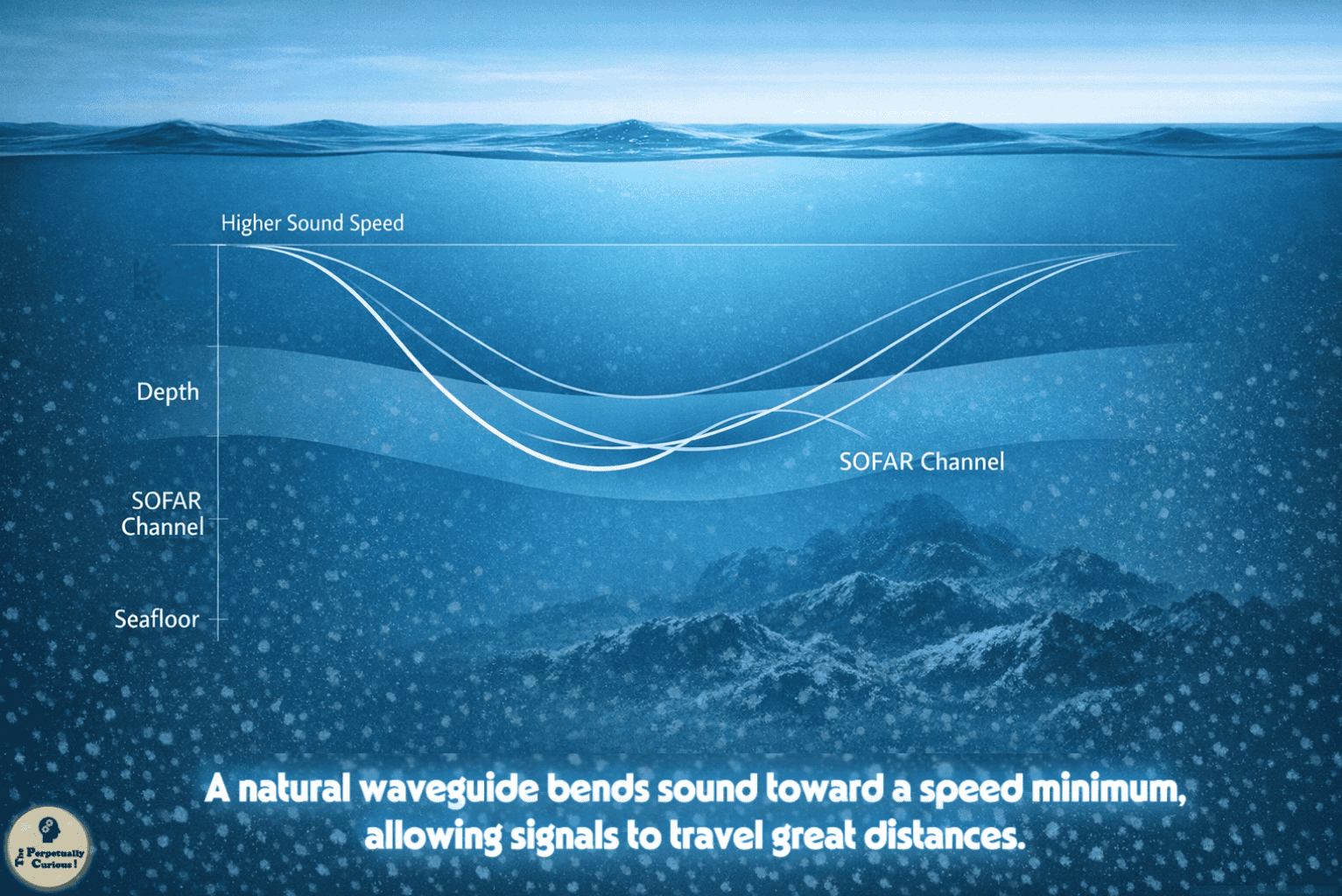
These variations create layers in the ocean where sound can bend, focus, or spread out. In some depth ranges, sound may be guided over long distances in what is commonly known as the SOFAR channel (Sound Fixing and Ranging channel), a natural acoustic waveguide in the deep ocean. In other regions, sound may be scattered or absorbed more quickly. For SONAR, this means that the same sound pulse can behave very differently depending on where and how it is used.
Understanding these physical principles provides the foundation for how active and passive SONAR systems are designed to work with the acoustic character of the ocean.
🎯 Active and passive SONAR in practice
Active SONAR systems send out a controlled sound pulse, often called a ping, and then listen for echoes. The time between the ping and the echo gives the range to a target, while the direction of the returning sound provides bearing. By combining range and bearing, a SONAR system can estimate where an object is located relative to the sensor. Some active systems use a single transducer, while others use arrays of many elements to form narrow beams and improve directional accuracy.
Passive SONAR systems do not transmit sound. Instead, they use sensitive underwater microphones, called hydrophones, to listen to sounds already present in the ocean. These sounds may come from ships, waves, or marine animals. Passive systems can often estimate the direction of a sound source, and with multiple listening points they may allow triangulation of its position. Arrays of hydrophones improve directionality by comparing the arrival times of sound at different sensors.
As these two approaches reveal different aspects of the underwater environment, the next step is to understand how the returning or ambient sound is interpreted and transformed into meaningful information.
📡 From echo to information
When an active SONAR pulse strikes an object, part of the sound energy is reflected back toward the source. The time delay between transmission and reception, multiplied by the speed of sound and divided by two, gives the distance to the object. For example, if an echo returns after about two seconds, and the sound speed is about 4,900 feet per second (about 1,500 meters per second), the object is roughly 4,900 feet (about 1,500 meters) away.
The strength of the echo can provide clues about the size, shape, and material of the target. A large, hard object such as a rock outcrop or a ship hull may return a stronger echo than a small or soft object. The frequency content of the echo can also change, especially if the target or the SONAR platform is moving. This effect, known as the Doppler shift, occurs when motion causes the frequency of the returning sound to increase or decrease, which can reveal relative movement. The way SONAR interprets these shifts has a useful connection to how radio waves carry information through changes in their own frequency and timing.
Passive SONAR works differently. Rather than sending a known signal and measuring its return, a passive system receives unknown sounds from the environment and analyzes their frequency patterns, timing, and direction of arrival to infer the nature and location of the source.
As these interpretations accumulate, they form the basis for mapping underwater landscapes, tracking objects, and studying marine life, allowing individual echoes and ambient sounds to become part of a larger picture of the ocean.
🗺️ Mapping the seafloor and hidden landscapes
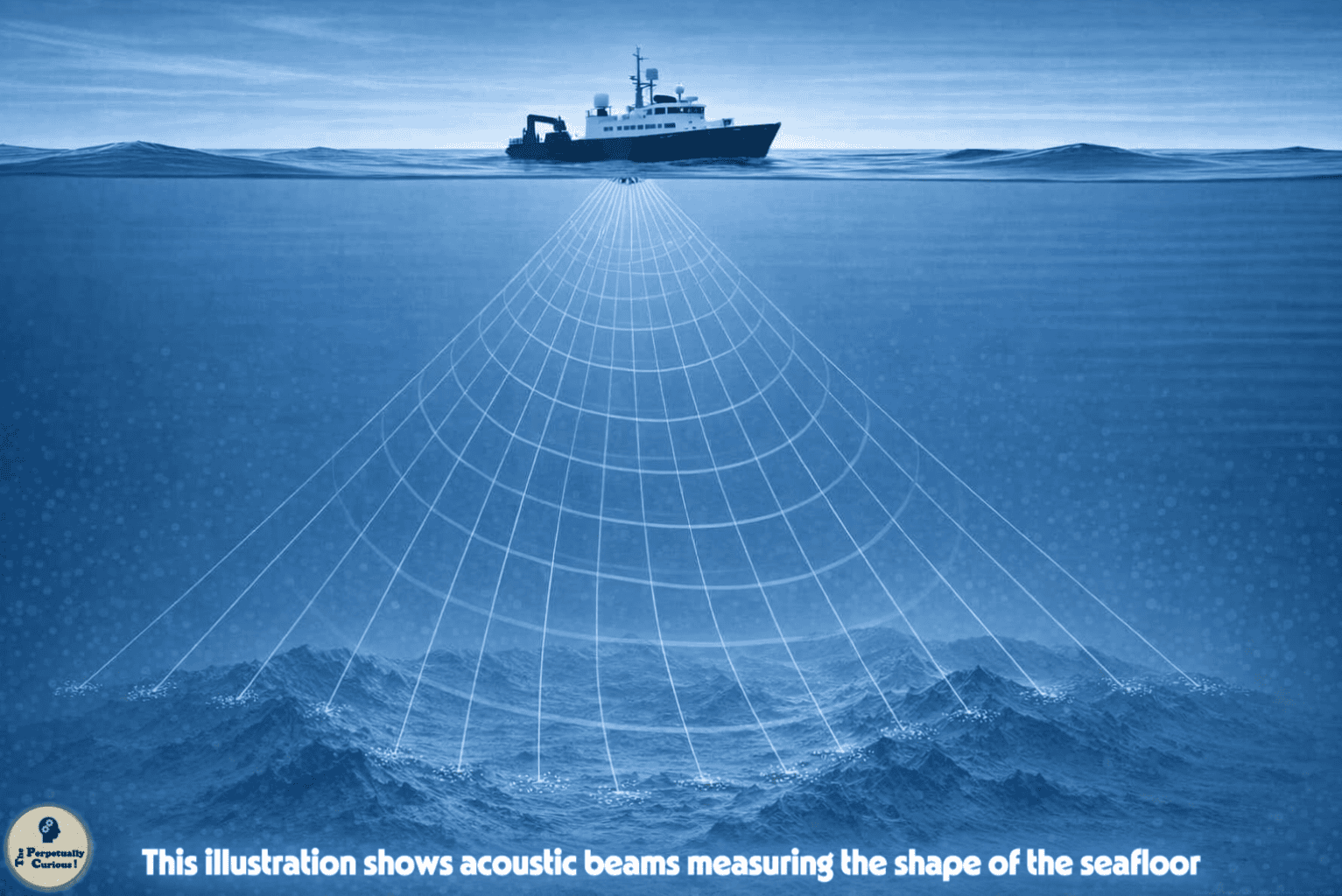
One of the most widely used applications of SONAR is seafloor mapping. Multibeam SONAR systems send out many narrow beams of sound that fan out beneath a ship. By measuring the travel time of echoes from each beam, these systems can create detailed maps of depth over wide swaths of seafloor. Many modern systems electronically steer these beams to cover large areas efficiently. Depth sounders on ships and small boats often use a simpler single-beam approach, sending a pulse straight down and measuring the time to the bottom.
Side-scan SONAR provides another perspective. Instead of focusing on depth alone, it sends sound to the sides and records the strength of the returning echoes. This produces image-like representations of the seafloor, where bright areas often indicate strong reflections and darker areas indicate weaker ones. Side-scan SONAR is frequently used to locate shipwrecks, debris fields, and other features that stand out from the surrounding bottom. These acoustic maps reveal details that are otherwise hidden from view, much like the way x-rays allow scientists to study structures that cannot be seen directly.
These mapping techniques are important for navigation, scientific research, and underwater archaeology. They help reveal underwater mountains, canyons, and plains that shape the habitats of many marine organisms. This connection between physical structure and living communities provides a natural path toward understanding how acoustic tools are also used to study life in the ocean.
🐋 Listening to life in the ocean
SONAR and related acoustic tools are often used to study marine life. Active acoustic systems can detect schools of fish, layers of plankton, and other organisms that reflect sound. The choice of frequency influences what can be detected, since different organisms reflect sound differently depending on their size and structure. For example, fish with swim bladders often produce strong echoes at certain frequencies.
Passive acoustic monitoring focuses on listening rather than transmitting. Many marine animals, including whales and dolphins, produce sounds that travel long distances underwater. By recording and analyzing these sounds, researchers can study migration patterns, communication, and habitat use. Arrays of hydrophones may allow scientists to estimate the locations of calling animals and to track their movements over time.
This biological perspective connects back to the earlier discussion of sound propagation. The same physical principles that guide SONAR pulses also shape how animal sounds travel through the ocean, which provides a natural path toward understanding how SONAR technology developed over time.
🕰️ A brief history of SONAR
The observation that sound carries well through water was noted as far back as the fifteenth century, but systematic development of SONAR technology did not begin until the early twentieth century. Research in underwater acoustics expanded rapidly during and after World War I, when the need to detect submarines became urgent, and it advanced even further during World War II as operational demands increased.
Over time, SONAR systems became more sophisticated. Advances in electronics, signal processing, and piezoelectric materials improved the sensitivity of hydrophones, increased the power of transmitters, and refined the analysis of echoes. Early SONAR receivers relied on glass‑based vacuum tubes to amplify faint signals, and the reliability of these tubes benefited from steady improvements in glass manufacturing, a craft whose precision shaped many branches of early twentieth‑century scientific instrumentation.
Today, SONAR is used in many contexts, including navigation, scientific research, search and recovery operations, underwater construction, and environmental monitoring. This historical view helps explain why SONAR is now so deeply integrated into ocean exploration and why it remains a central tool for sensing the underwater world.
🌌 SONAR as a way of sensing space
In most ocean environments, significant sunlight fades within roughly 300 to 600 feet (about 90 to 200 meters), depending on water clarity, while sound can travel for many miles under favorable conditions. SONAR takes advantage of this property, turning sound into a tool for sensing space where vision is limited. A single ping can reveal the presence of a seamount, the outline of a shipwreck, or the depth of a trench. A long listening record can reveal the passage of a distant storm or the seasonal movement of whales.
There is a quiet poetry in this process. SONAR does not illuminate the ocean in the way that a lamp illuminates a room. Instead, it listens for the way sound returns from surfaces and bodies, and from that pattern it infers shape and distance. The ocean becomes a resonant volume, where each echo is a small piece of information about a world that is mostly out of sight.
Pass this article along to someone curious and let the learning travel.
💡 Did You Know?
🌐 Some deep ocean layers allow sound to travel for hundreds or even thousands of miles because of a natural minimum in sound speed at depth, which traps and guides acoustic energy along the SOFAR channel.
🌏 Tsunamis can cross entire ocean basins as long‑wavelength waves, and their travel times help scientists understand how energy moves through the ocean.
🐋 Many baleen whales produce low‑frequency calls that can couple into the SOFAR channel, allowing their voices to travel remarkable distances across the ocean.
🎣 Many fish species have swim bladders that reflect sound strongly, which is why they appear clearly on some SONAR systems.
🧭 Before acoustic echo sounding, mariners commonly relied on lead lines to measure depth. In the early twentieth century, echo sounders made depth measurement much faster and more continuous.
🚢 The sinking of the Titanic in 1912 intensified interest in acoustic ranging and iceberg detection, while World War I more directly accelerated the development of practical underwater acoustic systems.
🌊 Freshwater environments such as lakes and reservoirs also use SONAR for depth measurement and ecological studies.
🔍 Some modern SONAR systems can detect subtle changes in seafloor texture, which helps identify sediment types and underwater features.
🗺️ The deepest known point in the ocean, the Challenger Deep in the Mariana Trench, has been mapped with modern multibeam sonar systems, which provide the most precise depth measurements ever made.
What does SONAR stand for?
SONAR stands for Sound Navigation and Ranging. It refers to techniques that use sound to detect, locate, and sometimes classify objects in water.
How fast does sound travel in seawater?
In typical ocean conditions, sound travels at about 4,900 feet per second (about 1,500 meters per second). This value can vary with temperature, salinity, and depth.
What is the difference between active and passive SONAR?
Active SONAR sends out sound pulses and listens for echoes, which allows it to measure range and direction to targets. Passive SONAR does not transmit sound and instead listens for sounds already present in the environment.
How is SONAR used to map the seafloor?
SONAR systems measure the time it takes for sound pulses to travel from a transmitter to the seafloor and back. By combining these travel times with the known speed of sound in water, they can calculate depth.
Can SONAR detect marine animals?
Some SONAR systems can detect schools of fish or other organisms that reflect sound. Passive acoustic monitoring is widely used to record and study the sounds produced by marine animals.
Why do SONAR systems use different frequencies?
Low frequencies travel farther but provide less detail, while high frequencies provide fine detail over shorter ranges. The choice depends on the purpose of the survey.
Can SONAR be used through ice or sediment?
Specialized upward‑looking sonar can measure the underside of sea ice by sending sound upward from below. Low‑frequency sub‑bottom profilers can penetrate some sediment layers to reveal buried structures, although performance depends on sediment type, thickness, and frequency.
Beneath the surface, sound becomes a traveler, carrying stories through shifting layers of depth and distance.
In its echoes, the ocean reveals shapes, histories, and quiet truths that light can never reach.
🌱 A gentle invitation to share
We kindly invite you to share and spread the word. By passing this article along to friends, colleagues, and fellow ocean enthusiasts, you help more people appreciate how sound reveals the hidden structure of the sea. Your quiet act of sharing may encourage someone else to look at a depth sounder, a nautical chart, or a recording of whale song with renewed curiosity.
“How SONAR Uses Sound to Map the Hidden Ocean Depths.” The Perpetually Curious!, May 2026.
https://www.theperpetuallycurious.org/articles/underwater-sound/Continue Exploring
Site Updates
Begin with the Updates page for new articles, site notes, and recently added pieces across The Perpetually Curious!