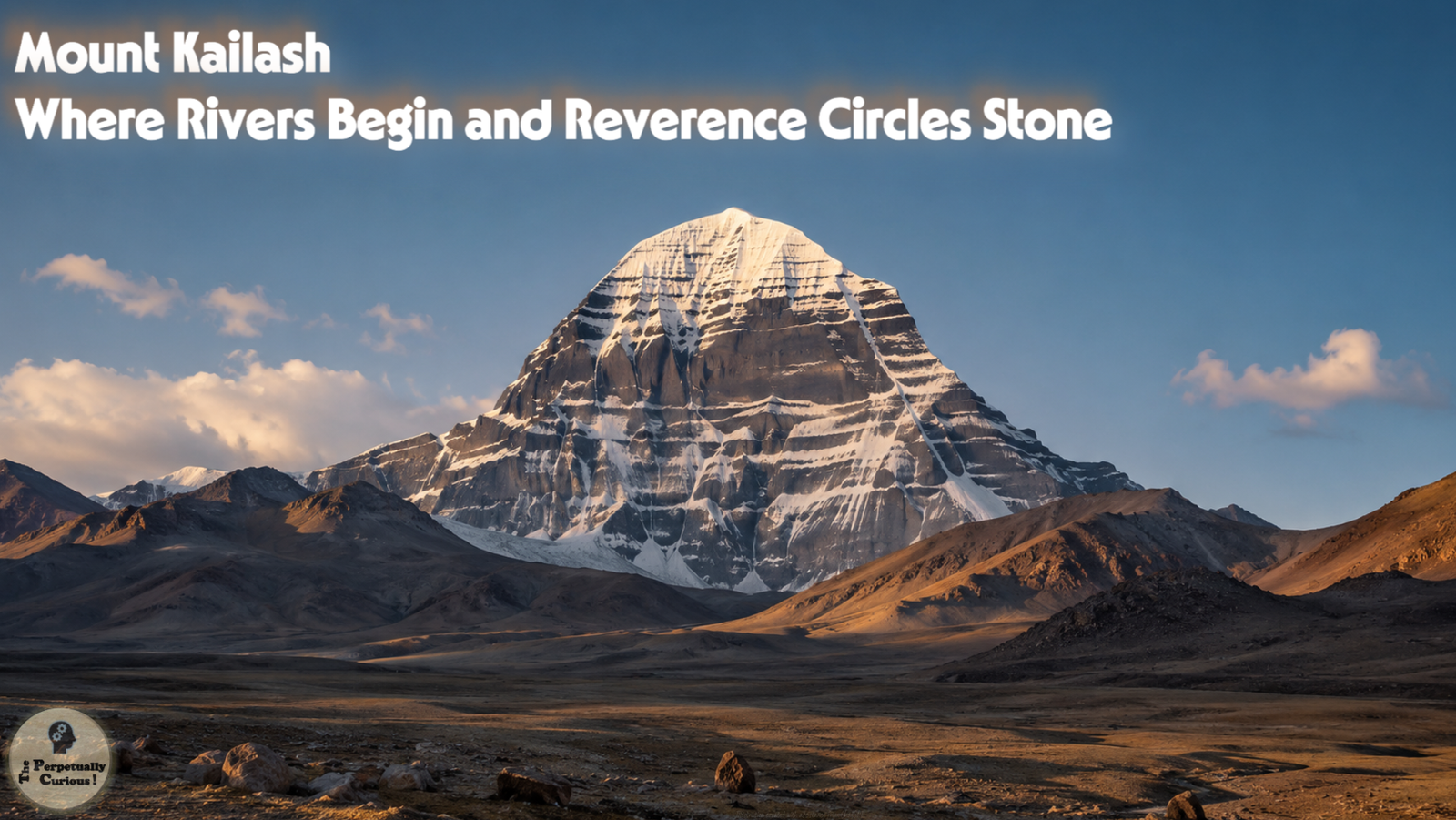
Mount Kailash rises on the western Tibetan Plateau as a solitary, snow-crowned peak that has shaped imagination, geography, and cultural memory for many centuries. Known in Tibetan as Gang Rinpoche, or Kangrinboqê, meaning Precious Jewel of Snows, it stands at about 21,778 feet (6,638 meters). It is not the tallest mountain in Asia, yet its presence feels singular. The mountain stands apart from surrounding summits, its strikingly regular faces catching light in ways that appear both austere and serene. Around this peak, rivers begin their long journeys, lakes reflect shifting skies, and several religious traditions locate some of their most meaningful narratives.
This article opens with the landscape itself, its position, its water, and its rock, and then moves outward toward the traditions and journeys that have made it one of the most recognized summits in the world. Each section builds on the previous one, tracing how a single mountain becomes a point of convergence in a landscape that feels both remote and deeply connected.
🌍 A solitary summit on the Tibetan Plateau
Mount Kailash stands within Ngari Prefecture in the Tibet Autonomous Region of China, positioned in the Gangdise Range of the Transhimalaya. The mountain rises sharply above the high plateau, its slopes often covered in snow that shifts with season, wind, and sunlight. Although the region is expansive, the mountain has a distinctive profile that becomes a visual anchor for the surrounding landscape.
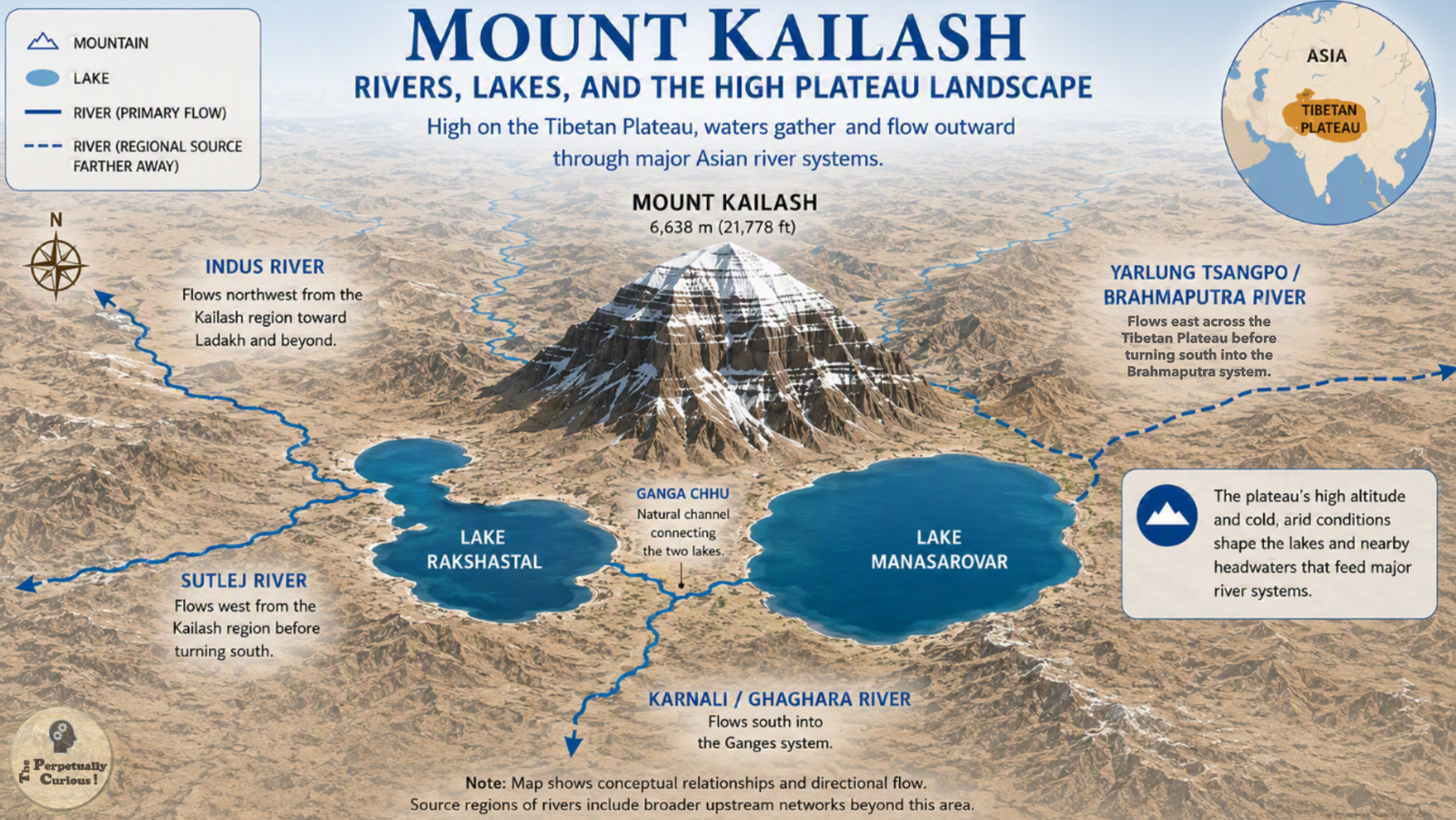
To the south lie two high altitude lakes that form a striking pair. Lake Manasarovar, at about 15,060 feet (4,590 meters), is a freshwater lake that receives water from the surrounding high altitude catchment. Nearby Rakshastal is a saline, endorheic lake, one with no drainage outlet, and it often appears darker or more muted in comparison, creating a visual contrast that has inspired symbolic interpretations for centuries. These lakes, together with the mountain, shape both the ecology and the cultural imagination of the region.
This high plateau environment, like other extreme regions, reveals how altitude, cold, and light shape both landscape and perception.
This physical setting provides the foundation for understanding how Mount Kailash influences water systems far beyond its immediate surroundings. The next section follows these waters outward and traces how a single massif becomes connected to distant plains and deltas.
🌊 Where great rivers find their first paths
Several major Asian river systems have their headwaters or early tributaries in the broader Kailash region. The Indus River flows northwest across the Tibetan Plateau toward Ladakh and beyond. The Sutlej River flows westward before turning south into India. The Yarlung Tsangpo, which becomes the Brahmaputra, begins farther east on the Tibetan Plateau, with its primary source at the Angsi Glacier. The Karnali River, part of the larger Karnali and Ghaghara system, flows southward into Nepal and contributes to the Ganges basin.
Just as the Great Lakes show how large water systems can shape regions beyond their immediate shores, the rivers near Mount Kailash carry water from this high plateau to plains and deltas far away.
The outward movement of water from this region mirrors the inward movement of meaning that different cultures bring to the mountain. As rivers flow away from Kailash, stories and traditions flow toward it, creating a convergence of physical and symbolic pathways.
🕉 A mountain at the crossroads of faiths
Mount Kailash holds significance in Hinduism, Buddhism, Jainism, and the Bon tradition of Tibet. Each tradition approaches the mountain with its own narratives, yet all regard it as a place of profound meaning.
In Hindu traditions, Mount Kailash is associated with Shiva and is often described as a place of meditation and stillness. Lake Manasarovar is linked with purity and creation, forming a symbolic pair with the mountain.
In Buddhist contexts, the mountain is connected with Mount Meru, the cosmic axis in Buddhist cosmology. It is associated with deities such as Chakrasamvara and is integrated into a broader sacred geography that includes other peaks and pilgrimage sites.
In many Jain traditions, the mountain they call Ashtapada is regarded as the place where Rishabhadeva, the first Tirthankara, attained liberation. In the Bon tradition, Mount Kailash is known as Tise, the Nine‑Stacked Swastika Mountain, and is associated with the sky goddess Sipaimen within a cosmology that places the mountain at the center of spiritual origin and power.
Mount Kailash belongs to a wider family of revered landscapes and living symbols, much like the Sacred Peepal Tree, where natural form, cultural memory, and ecological presence meet.
These traditions differ in theology, story, and ritual practice, yet they converge in reverence for the mountain. The convergence of multiple traditions upon a single geographic feature gives the mountain an unusually layered place in sacred geography.
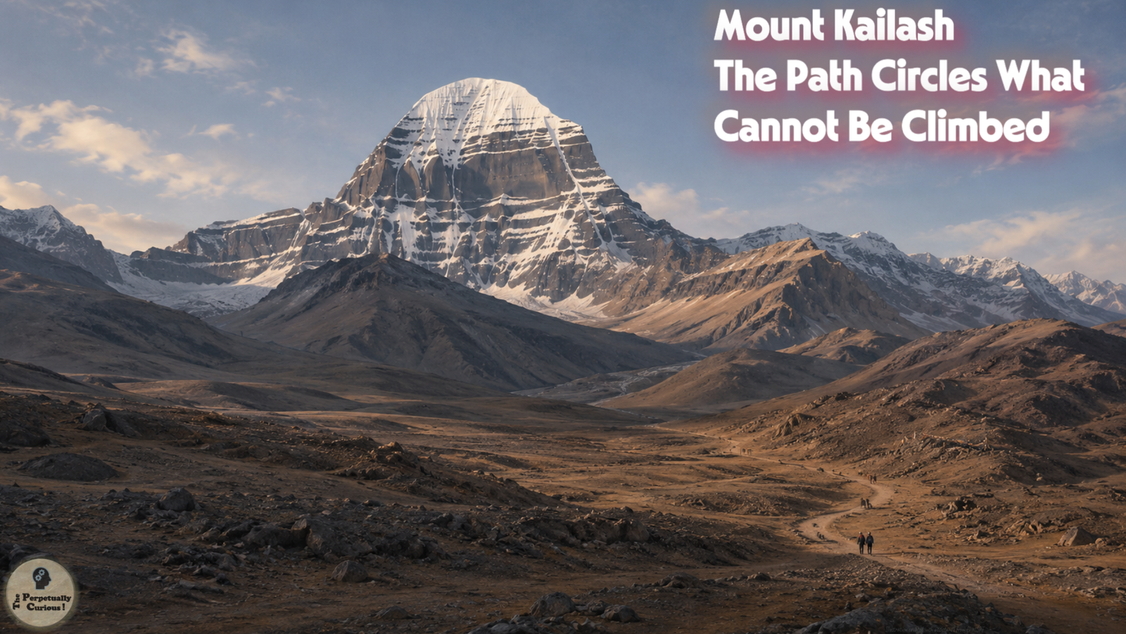
The practice that brings many visitors to the region is not ascent but circumambulation, the act of walking around the mountain in a continuous circle.
🚶 The Kailash Kora: Walking a circle of meaning
The Kailash Kora is a circumambulation route of about 32 miles (52 kilometers) that circles the mountain and is commonly completed over three days. Pilgrims and visitors begin near Darchen, a settlement that serves as the starting point for the journey. The route rises from approximately 15,000 feet (about 4,575 meters) and crosses the Dolma La pass at about 18,471 feet (5,630 meters), where thin air and shifting weather create challenging conditions.
Pilgrims in Hindu and Buddhist traditions typically walk clockwise, while some Bon and Jain practitioners walk counterclockwise. The path passes shrines, prayer flags, and viewpoints where the mountain appears in new profiles. Seasonal conditions influence the experience, with summer offering clearer access and winter bringing snow that may close parts of the route.
The Kora transforms belief into movement. It is a physical journey that reflects inner intention, and it is also a way of experiencing the landscape in a continuous circle, where each step reveals new angles of rock, ice, and sky.
🛂 Access, permits, and a carefully managed frontier
Mount Kailash lies within a region that is geographically remote and administratively controlled. Travel to the Tibet Autonomous Region generally requires special authorization in addition to a Chinese visa, and requirements can change. Because the mountain is near sensitive border areas, visits are usually coordinated through authorized travel arrangements rather than independent access.
Climbing Mount Kailash is prohibited. There has been no recorded ascent, and the prohibition reflects both religious reverence and administrative policy. The mountain remains intentionally untouched, preserving its status as a sacred summit.
Beneath the permits and pathways lies the mountain itself, shaped by rock, ice, and geological time that precede every human narrative.
🔬 Snow, stone, and sky: Scientific perspectives on Kailash
Mount Kailash is part of the Gangdise or Transhimalayan system, shaped by tectonic processes associated with the collision of the Indian and Eurasian plates. The region includes Gangdese volcanic and intrusive rocks as well as the Oligocene–Miocene Kailash Formation, whose sedimentary units have been uplifted, glaciated, and shaped by erosion and weathering over many millions of years. The Transhimalaya differs from the main Himalayan arc in both age and composition. While the Himalaya formed largely from the uplift of marine sediments, the Transhimalaya contains volcanic and intrusive rocks as well as older sedimentary layers. In the wider Kailash basin, conglomerate, sandstone, shale, and locally associated volcanic or igneous material contribute to the contrasting tones of dark rock that appear where snow recedes, a visual contrast that has drawn symbolic interpretation across traditions.
Snow distribution on the mountain varies with wind patterns, sun exposure, and seasonal conditions. Some faces retain snow longer, while others reveal dark rock earlier in the year. The mountain’s near-symmetrical appearance has inspired symbolic interpretations, yet this symmetry arises from natural processes rather than deliberate design.
The mountain’s snowfields also connect with the quiet physics of light scattering in snow and ice, where countless crystal surfaces scatter light and influence how a landscape is seen.
🌱 A fragile high altitude environment
The region around Mount Kailash is a delicate high altitude ecosystem. Vegetation is sparse, often limited to hardy grasses and shrubs that grow slowly because of thin soil and cold temperatures. Plant recovery from disturbance may take many years. Wildlife is adapted to extreme conditions, with species such as the Tibetan wild ass, foxes, and several birds inhabiting the plateau.
The thin air, strong sunlight, and cold temperatures around Mount Kailash are local expressions of Earth’s living atmosphere, where altitude changes how climate and life are experienced.
Pilgrimage seasons concentrate human activity into specific months, increasing pressure on trails, campsites, and water sources. Waste management and erosion control become important considerations, especially in areas where soil is thin and easily disturbed.
🌌 A mountain of many paths
Mount Kailash can be understood as a place where many paths converge. Rivers flow outward from its vicinity toward distant seas. Pilgrims walk around its base in circles that are both physical and symbolic. Scientific inquiry traces the history of its rocks and ice, while cultural narratives locate deities, enlightened beings, and cosmic structures upon its slopes.
Near sunrise or sunset, the sky around Mount Kailash may glow with colors shaped by atmospheric scattering, showing how light can change the way snow, stone, and sky are perceived.
The mountain remains a peak of stone and snow, shaped by natural forces and observed from afar. Yet it is also a place where ideas of origin, center, and transcendence are explored. Its significance does not depend on ascent but on presence, reflection, and the quiet recognition that some landscapes hold meaning precisely because they remain beyond direct human conquest.
Pass this article along to someone curious and let the learning travel.
💡 Did you know?
🧭 The near-symmetrical shape of Mount Kailash has inspired symbolic interpretations for centuries, yet this appearance arises from natural processes of uplift and erosion rather than deliberate design.
🌬 Wind patterns around the mountain influence snow distribution, creating faces that appear dramatically different depending on season and sunlight.
🌊 Lake Manasarovar is one of the highest freshwater lakes in the world and receives freshwater from the surrounding high altitude catchment. Nearby Rakshastal is a saltwater, endorheic lake with no drainage outlet, losing water mainly through evaporation, which concentrates its mineral content over time. The two lakes are connected by the natural Ganga Chhu channel, and in 2004 they were jointly designated as part of the Mapangyong Cuo Ramsar Wetland complex.
📍 The headwaters of several major river systems begin in the broader region around Mount Kailash, contributing to its role in an important high plateau water landscape.
🏔 The wider Himalayan and Tibetan Plateau region preserves evidence of the ancient Tethys Ocean and later continental collision, while the Kailash region records complex uplift, sedimentation, faulting, and erosion.
🌗 Shadow patterns on Mount Kailash shift throughout the day, creating alternating bands of light and darkness that have inspired symbolic interpretations in several traditions.
🐾 Wildlife around the mountain includes species adapted to extreme altitude, such as the Tibetan wild ass and the Himalayan marmot, which inhabit the wider plateau region.
📡 Satellite data helps researchers study snow cover, glacial patterns, and seasonal changes around Mount Kailash, offering new insights into its high altitude environment.
Where is Mount Kailash located?
Mount Kailash is located in Ngari Prefecture in the Tibet Autonomous Region of China, within the Gangdise Range of the Transhimalaya.
How high is Mount Kailash?
Mount Kailash rises to about 21,778 feet (6,638 meters) above sea level.
Why is Mount Kailash considered sacred?
Mount Kailash is regarded as sacred in Hinduism, Buddhism, Jainism, and the Bon tradition, each of which associates the mountain with significant spiritual narratives.
Has anyone climbed Mount Kailash?
There is no recorded ascent of Mount Kailash, and climbing is prohibited because of its sacred status.
Is Mount Kailash part of the Himalaya?
Mount Kailash is part of the Transhimalaya, a range distinct from the main Himalayan arc.
Why do multiple religions revere the same mountain?
The convergence of traditions may reflect the mountain’s striking form, its position near ancient trade routes, and its association with early cosmological narratives.
Which rivers originate near Mount Kailash?
The Indus, Sutlej, Yarlung Tsangpo/Brahmaputra, and Karnali/Ghaghara river systems have headwaters or early tributaries in the broader region around Mount Kailash.
How old is the mountain geologically?
The rocks and formations around Mount Kailash record many millions of years of sedimentation, uplift, faulting, and erosion linked to Himalayan and Tibetan Plateau tectonic history.
Why are Lake Manasarovar and Rakshastal so different?
Lake Manasarovar is one of the highest freshwater lakes in the world and receives freshwater from the surrounding high altitude catchment. Rakshastal is an endorheic lake with no drainage outlet, so minerals concentrate over time as water evaporates, making it saline. This creates a rare high altitude pairing of contrasting lake types.
Why do the lakes have different colors?
Manasarovar often appears blue or turquoise because it is a freshwater lake with clearer water. Rakshastal may appear darker or more muted because its saline water has higher mineral content and lower biological activity, though both lakes can appear blue under clear skies.
Do the two lakes ever mix or exchange water?
The two lakes are connected by a short natural channel called the Ganga Chhu. Flow through this channel varies with the water level of Lake Manasarovar. In 2004, both lakes were jointly designated as part of the Mapangyong Cuo Ramsar Wetland complex.
Why is Rakshastal shaped like a crescent?
Rakshastal’s crescent shape reflects the form of its basin, which was shaped by tectonic uplift and erosion. The shape has also influenced cultural interpretations of the lake.
Are there fish or aquatic life in either lake?
Manasarovar supports limited freshwater life, while Rakshastal’s high salinity and lack of an outlet reduce biological activity. Neither lake has extensive aquatic ecosystems.
Are there mysterious sounds over Lake Manasarovar?
There are anecdotal reports of unusual or resonant sounds near Lake Manasarovar, but there is no confirmed scientific evidence for a consistent acoustic phenomenon. Such accounts are often understood within cultural and spiritual storytelling.
Is Rakshastal associated with Ravana?
The association between Rakshastal and Ravana is documented in Hindu sacred literature. The lake is also known as Ravan Tal, and tradition describes it as the site of Ravana’s acts of devotion to Shiva.
Why is Rakshastal sometimes described as austere or lifeless?
Rakshastal’s high salinity, lack of an outlet, and strong evaporation reduce biological activity, which contributes to its reputation as an austere lake.
What is the Kailash Kora?
The Kailash Kora is a 32-mile (52-kilometer) circumambulation route around the mountain, undertaken by pilgrims and visitors.
How long has the Kora tradition existed?
The practice of circumambulation has existed for many centuries, with roots in early Tibetan, Hindu, and Bon traditions.
What is the environment like around Mount Kailash?
The environment is a high altitude plateau with thin air, strong sunlight, cold temperatures, and sparse vegetation.
Are there glaciers on Mount Kailash?
There are small glaciers and perennial snowfields on and around the mountain, although they are not as extensive as those found on higher Himalayan peaks.
Is Mount Kailash a volcano?
Mount Kailash is not a volcano. It belongs to a tectonically uplifted Transhimalayan landscape shaped by sedimentary, metamorphic, and igneous geological history.
Is Mount Kailash visible from space?
Mount Kailash can be observed in satellite imagery, where its distinctive shape and surrounding lakes are clearly visible.
What permits are generally required to visit the region?
Visitors typically require a Tibet Travel Permit and additional authorizations because of the region’s proximity to international borders.
When is the region most accessible?
The region is generally most accessible during summer months, when snow is reduced and roads are more passable.
A stillness gathers around the mountain, where light moves across stone and snow in quiet rhythms.
In this high place, water, story, and sky meet without urgency, as if the world pauses to listen.
Some landscapes speak softly, yet their presence lingers long after the path has turned away.
🌺 A gentle invitation to share
Some landscapes invite reflection, and some stories travel farther when carried by many voices. If this piece offered a moment of stillness or a new way of seeing Mount Kailash, we warmly invite you to share it with others who may appreciate its quiet layers of meaning. Your support helps more readers discover the mountain’s beauty, its cultural depth, and the many paths that meet at its slopes.
Thank you for helping this story find its way into wider circles, one thoughtful reader at a time.
Continue Exploring
Site Updates
Begin with the Updates page for new articles, site notes, and recently added pieces across The Perpetually Curious!
🎥 Watch the Mount Kailash story in motion
Some landscapes reveal new dimensions when seen in motion. The quiet rise of the summit, the sweep of the Tibetan Plateau, and the reflective surface of Lake Manasarovar take on a different presence when carried by light, distance, and time. These videos extend the article visually, first through the lake and its high altitude setting, then through a closer view of Mount Kailash within its wider landscape.
Mount Kailash and the sacred landscape
This video reflects the central role of the mountain in the article, presenting Mount Kailash as a landform, a place of pilgrimage, and a summit whose meaning is shaped by geography, reverence, and distance.
Lake Manasarovar and the high plateau
This video offers a visual companion to the lake sections of the article, showing Lake Manasarovar within the broader Kailash region, where water, sky, altitude, and cultural meaning meet.