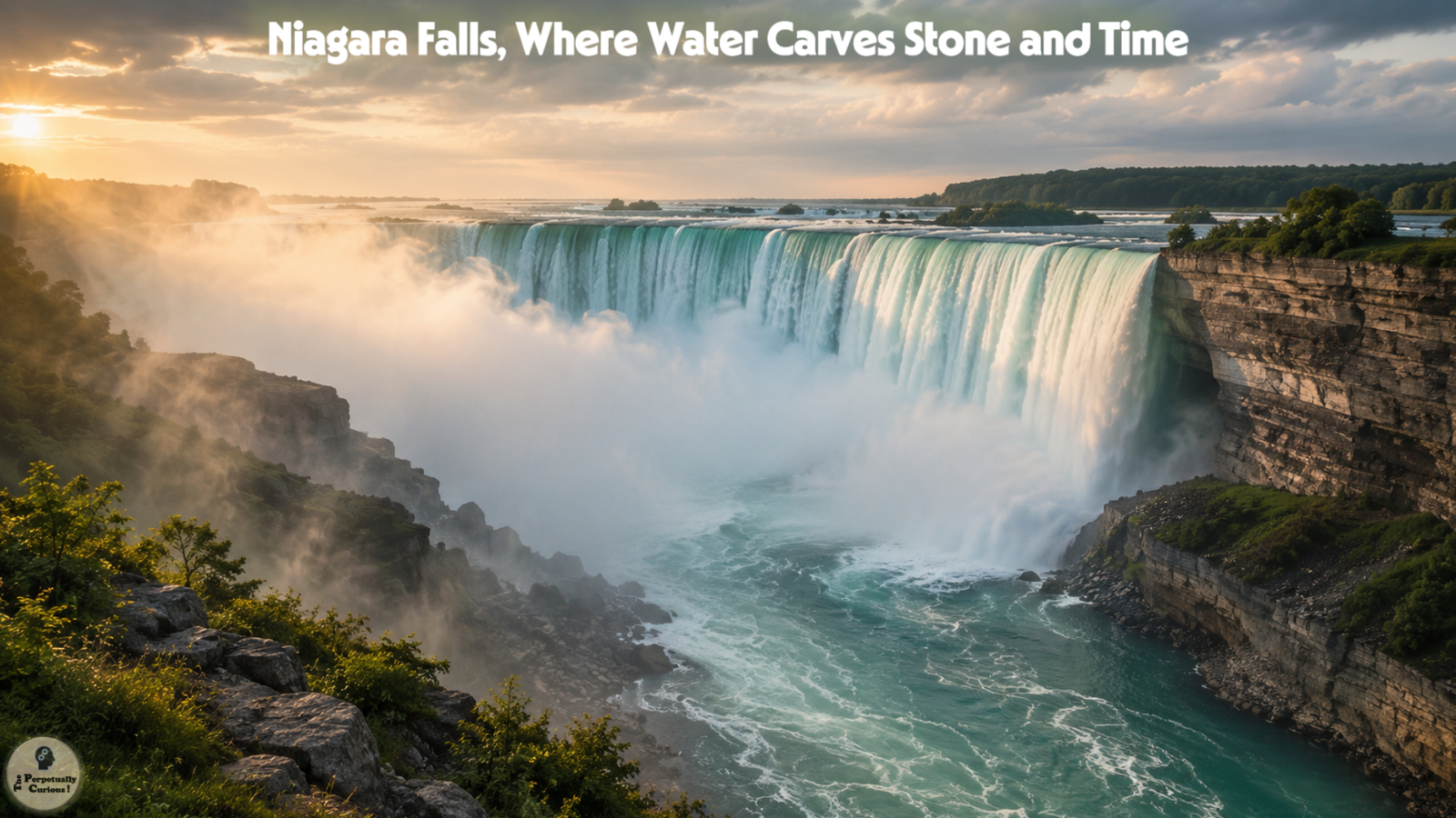
Niagara Falls is a place where water, stone, air, and memory converge. The roar that rises from the gorge carries the weight of ancient seas, vanished glaciers, and the long, patient work of erosion. To stand before the falls is to feel time moving in two directions at once: backward into deep geological history and forward into the continuous reshaping of the landscape. The journey of this water begins far upstream, in the vast Great Lakes basin, where the upper Great Lakes ultimately drain toward Lake Erie before continuing north through the Niagara River. From there, the river flows toward Lake Ontario, continuing through the St. Lawrence River before reaching the Atlantic Ocean. This immense watershed sets the stage for the creation, evolution, and enduring presence of Niagara Falls.
🧊 From ice and stone: How Niagara Falls was born
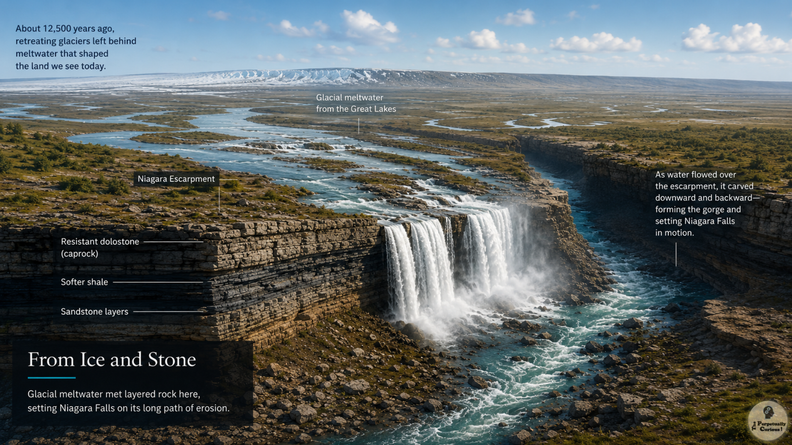
The origins of Niagara Falls trace back to the end of the last ice age, when massive glaciers covered much of the northern continent. As the climate warmed approximately 12,500 years ago, the retreating ice carved basins that filled to become the Great Lakes. Meltwater from these lakes sought pathways toward the ocean, and one of those pathways became the Niagara River. To understand Niagara Falls fully, it helps to see it within the Great Lakes system, where vast inland waters, elevation change, and glacial history shape the river’s movement from Lake Erie toward Lake Ontario.
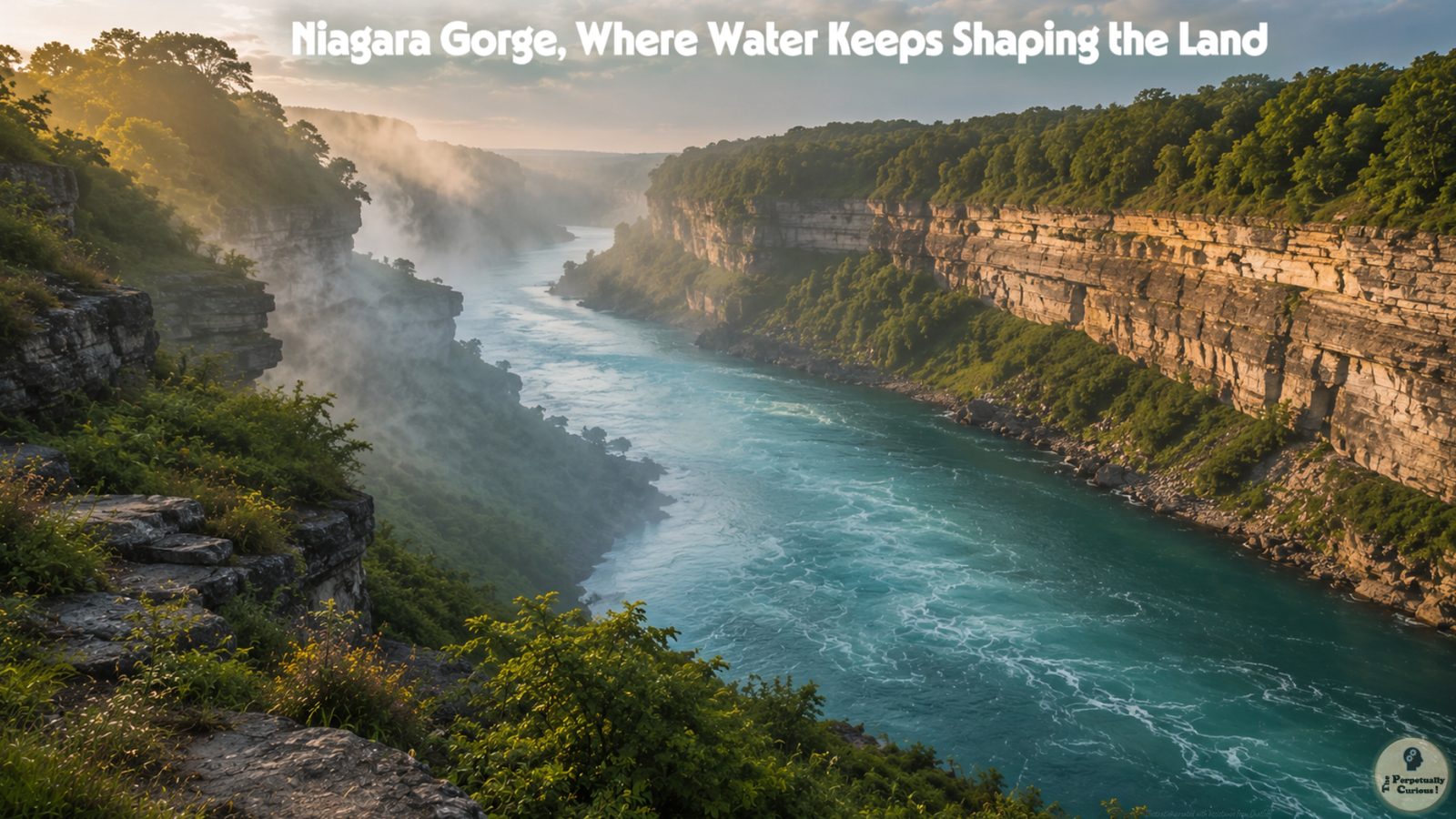
As the river flowed north from Lake Erie toward Lake Ontario, it encountered the Niagara Escarpment, a long ridge of sedimentary rock composed of a hard dolostone and limestone caprock over softer shale and sandstone layers. Water spilled over the escarpment at a low point, initiating the formation of a waterfall. Over thousands of years, the falls retreated upstream as the softer rock eroded more quickly than the harder caprock. This process carved the Niagara Gorge, a steep and winding channel that records the movement of the falls through time.
The geological story of Niagara is therefore one of water meeting stone, of ancient seas transformed into layered rock, and of glaciers reshaping the land before giving way to rivers that continue the work of change.
💧 Measuring immensity: Height, flow, and scale
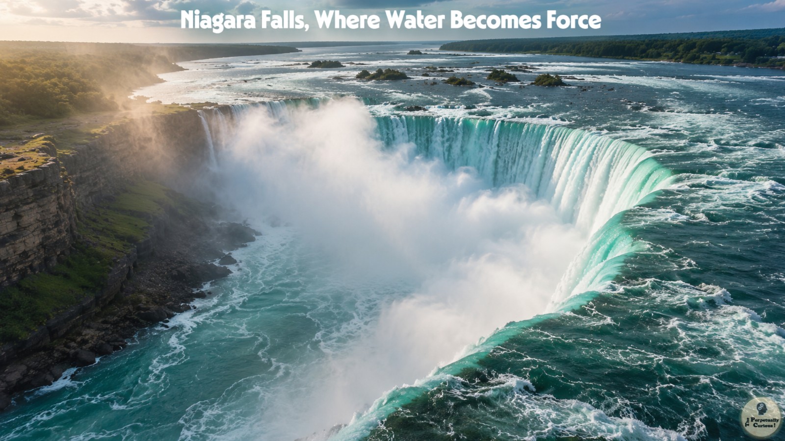
Niagara Falls is defined not by height alone but by the combination of height and volume. Horseshoe Falls, the largest of the three waterfalls, drops about 188 feet (about 57 meters) into the lower river. The American Falls share a similar total height, though the visible drop to the talus slope ranges between about 70 and 110 feet (about 21 to 34 meters). Bridal Veil Falls, narrow and graceful, completes the trio.
The flow of water is immense. During peak daytime hours, more than about 6 million cubic feet of water per minute (about 168,000 cubic meters per minute) may pass over the crest lines. Horseshoe Falls carries most of this flow across a curved brink about 2,200 feet (about 670 meters) wide. Above the falls, the river accelerates through rapids that may reach speeds of about 25 miles per hour (about 40 kilometers per hour), creating a sense of gathering momentum before the plunge.
The immense force of the falling water illustrates how kinetic energy scales with mass and velocity, a physical relationship that also underlies the physics of tsunamis, where moving water masses carry energy across vast distances. Mist rises continuously from the base of the falls, shaped by wind, temperature, and the force of the water. When low sunlight passes through the mist, warm tones can appear in the spray, a reminder that light and water produce shared optical effects visible everywhere from gorge-level mist to the red and orange glow at sunset across the open sky.
A visual companion to this landscape of falling water, mist, and scale is available in the Niagara Falls visual journey.
🌿 Life around the mist: Ecosystems and habitats
The Niagara River corridor supports a diverse array of habitats shaped by water flow, steep terrain, and microclimates created by mist and shade. Fast‑moving, well‑aerated water in the Niagara River supports fish species adapted to strong currents. Along the gorge walls, mosses, lichens, ferns, and shrubs grow in pockets where soil has accumulated. The region lies near the northern edge of the Carolinian Life Zone, a biogeographic region known for relatively mild conditions and a diversity of plant and animal species more commonly found further south. Moisture rising from the gorge and the mineral‑laden air of the canyon can carry subtle atmospheric scents that share a family resemblance with the smell of rain, where water and earth combine to awaken the senses. These microclimates also illustrate broader patterns found within earth’s living atmosphere, where temperature, humidity, and air movement shape local conditions. Migratory birds follow the river corridor in spring and fall, using it as a natural guide. In winter, ice formations create temporary habitats and alter the flow of water along the riverbanks. These seasonal rhythms, shaped over millennia, formed the living world that Indigenous peoples first came to know, and that continues to frame every human story told about this place.
🌾 Stories and names: Indigenous presence and early accounts
Long before written records, Indigenous peoples lived along the Niagara River and understood the falls as part of a broader cultural and ecological landscape. The name “Niagara” is widely believed to derive from an Iroquoian word, though interpretations vary. Some suggest meanings related to “thundering waters,” while others point to the idea of a “neck” or “strait,” reflecting the river’s role as a connector between lakes.
For communities such as the Neutral, the falls and surrounding lands held significance as places of travel, sustenance, and meaning. Oral traditions and archaeological evidence indicate long‑standing relationships with the river, shaped by observation, respect, and adaptation.
European accounts began in the seventeenth century, when explorers and missionaries described the falls in vivid terms, although earlier French expeditions had passed near the region without leaving detailed descriptions. Louis Hennepin wrote of a “prodigious cadence of water,” while later visitors struggled to capture the experience in words. These early descriptions reveal a pattern that continues today, as observers seek language that can hold both the physical reality and the emotional resonance of the falls.
🏛️ From spectacle to shared landscape: Tourism, engineering, and hydropower
By the nineteenth century, Niagara Falls had become a destination for travelers who came to witness its scale and beauty. Artists, writers, and photographers sought to capture its form, while pathways, viewing areas, and nearby accommodations developed to support growing interest.
At the same time, the river’s immense flow attracted attention as a potential source of energy. Engineers designed systems to harness part of the water for hydropower, and agreements between Canada and the United States established frameworks for dividing flow between scenic preservation and energy production. During peak tourist hours, more water is typically allowed to pass over the falls, while at other times a larger share may be diverted to power stations.
In 1969, the American Falls were temporarily dewatered to allow geologists to study rock stability. The exposed cliff revealed layers of talus and fractures, offering insights into erosion and safety concerns. Events such as this highlight the balance between scientific inquiry, public interest, and the preservation of natural character. That spirit of careful inquiry has since broadened into a sustained commitment to ecological and geological stewardship.
🌍 Watching the future: Conservation, erosion, and changing perspectives
Niagara Falls continues to evolve as water erodes rock and as human decisions influence flow patterns and land use. Historically, the falls retreated upstream at an average rate of about 5 feet (about 1.5 meters) per year between 1842 and 1905, although this rate varied over time. Modern flow regulation has reduced the current rate to less than 1 foot (about 0.3 meters) per year. Conservation efforts focus on protecting habitats, maintaining green spaces, and monitoring rock stability. The gorge and surrounding areas are managed to support both ecological integrity and visitor access. Water quality, fish migration, and the broader health of the Great Lakes system are also important considerations, reflecting the interconnected nature of the watershed. The slow reshaping of the gorge mirrors the long‑term movement of coastal sediment, where water continually transports and rearranges the materials that define a landscape. These forces work on timescales that dwarf a human lifetime, yet their cumulative effect is visible in every overhang, fracture, and carved wall of the gorge.
In this ongoing dialogue between water and stone, Niagara Falls continues to remind observers that even the most powerful landscapes are works in progress.
Pass this article along to someone curious and let the learning travel.
💡 Did You Know?
🌫️ Niagara Falls is composed of three waterfalls rather than one, with Horseshoe Falls carrying most of the river’s flow.
🕳️ The plunge pool beneath Horseshoe Falls reaches a depth of about 100 feet (about 35 meters), carved over time by the force of falling water.
🌀 The Niagara Whirlpool formed as the river encountered a buried ancient gorge, creating a dramatic swirling basin.
🌈 The mist rising from the falls often produces rainbows on sunny days, shaped by the angle of sunlight and the density of water droplets.
❄️ In winter, ice formations can create striking scenes along the river, although the falls themselves do not freeze solid due to the volume and movement of water.
🔊 The roar of the falls changes with humidity, wind, and temperature, creating a shifting soundscape that visitors may notice at different times of day.
🌙 Under the right conditions, the mist can refract moonlight into pale lunar rainbows, visible only at night.
🧭 The Niagara River flows north because Lake Erie sits higher than Lake Ontario, so the local slope carries water toward the lower lake.
🌬️ Winter temperature inversions can trap mist close to the ground, creating dense fog banks that drift along the gorge.
🐚 Fossils found in the gorge include corals and brachiopods that lived in shallow seas more than 400 million years ago.
🌊 Although the falls have never fully frozen, an ice jam at the Lake Erie outlet and upper Niagara River in 1848 temporarily stopped most flow for up to 40 hours.
✨ The pale glow that sometimes appears in winter mist is influenced by the same optical scattering properties that give snow whiteness its characteristic brightness.
🌅 At sunrise, the interplay of mist and low light can create subtle gradients reminiscent of the geometry of dawn, where illumination reveals delicate atmospheric structure.
🧊 Seasonal ice formations around the falls share visual and structural qualities with antarctic ice, where temperature and light interact to create intricate patterns.
💧 Horseshoe Falls carries roughly 90 percent of the water that passes over Niagara Falls, while American Falls and Bridal Veil Falls receive most of the remaining visible crest flow. Additional water may be diverted for hydropower under regulated flow agreements.
💦 The water flowing over Niagara Falls today is often described as fossil water, a legacy of the last ice age; only about one percent of the Great Lakes volume is renewed annually by precipitation, runoff, and groundwater.
🧪 The Niagara River carries about 60 tons (about 54 metric tonnes) of dissolved minerals and finely ground rock over the falls each minute, helping give the water its distinctive turquoise‑green color.
Where is Niagara Falls located?
Niagara Falls is situated on the Niagara River, which forms part of the border between Ontario in Canada and New York in the United States.
How many waterfalls make up Niagara Falls?
Niagara Falls consists of Horseshoe Falls, American Falls, and Bridal Veil Falls.
How tall is Niagara Falls?
The height is commonly given as about 188 feet (about 57 meters), with variations depending on the specific waterfall.
How much water flows over the falls?
During peak daytime periods, more than about 6 million cubic feet of water per minute (about 168,000 cubic meters per minute) may pass over the crest lines.
How fast is the water moving just before it goes over the falls?
The river accelerates through the upper rapids to speeds of about 25 miles per hour (about 40 kilometers per hour) before reaching the crest.
Can Niagara Falls freeze?
The falls do not freeze solid due to the volume and movement of water. However, in 1848 an ice jam at the Lake Erie outlet and upper Niagara River temporarily stopped most flow for up to 40 hours.
Why does the water appear turquoise?
The color results from dissolved minerals and finely ground rock particles suspended in the water, which scatter shorter wavelengths of light to produce green and turquoise hues. The suspended sediment includes very fine glacially derived particles that interact with sunlight in ways similar to alpine lakes, enhancing the distinctive color.
How old is Niagara Falls?
The falls began forming at the end of the last ice age, approximately 12,500 years ago.
How loud is Niagara Falls?
Sound levels near Horseshoe Falls often reach about 90 decibels, comparable to the noise of heavy traffic.
Does the sound of the falls change with the seasons?
Yes. Humidity, wind, and temperature influence how sound travels, creating subtle seasonal variations.
Does the volume of water change throughout the year?
Seasonal variations in precipitation and snowmelt influence the flow of the Niagara River. International agreements also regulate water diversion for hydropower.
Why does the Niagara River flow north?
The river follows the natural topographic gradient between Lake Erie at about 569 feet (about 173 meters) and Lake Ontario at about 246 feet (about 75 meters), a slope that runs northward in this region.
What is the 1950 Niagara Treaty?
It is a bilateral agreement between Canada and the United States that regulates the minimum volume of water flowing over the falls during daytime tourist hours and at night, balancing scenic preservation with hydroelectric power generation.
What determines how much water is diverted for hydropower?
Diversion levels follow the 1950 Niagara Treaty, which sets minimum scenic-flow requirements and allows greater diversion at night.
How deep is the Niagara Whirlpool?
Some measurements indicate depths reaching about 125 feet (about 38 meters). The depth varies across the basin because the whirlpool occupies the widened mouth of the buried St. David’s Gorge, an ancient river channel carved long before the modern Niagara River existed. Sediment movement, rotational flow, and the geometry of the underlying bedrock all contribute to subtle changes in depth over time.
Do fish migrate through the river?
Fish move through upper and lower Niagara River habitats, but the falls form a major natural barrier between Lake Erie and Lake Ontario for many species. Human-built canals have allowed some species to bypass that natural barrier.
How do winter ice bridges form?
Ice bridges develop when ice, slush, and frozen spray accumulate near the base of the falls, sometimes forming thick masses across parts of the lower river. These formations arise from a combination of cold air temperatures, persistent mist, and the continuous production of frazil ice in turbulent water. Although visually striking, these ice accumulations are dynamic and constantly reshaped by flow, wind, and temperature shifts.
What is the mist from the falls made of?
The mist consists primarily of fine water droplets, naturally aerosolized by the force of the falls, and carries the mineral character of the river water from which it forms. Its appearance and density vary with wind, humidity, and temperature, creating the shifting veils that define the atmosphere around the gorge.
Why does the mist sometimes look blue or white?
The color depends on droplet size, sunlight angle, and scattering processes similar to those that influence snow brightness. Larger droplets tend to scatter light more uniformly, producing a pale white appearance, while smaller droplets can emphasize shorter wavelengths, creating faint bluish tones. Atmospheric humidity and background light also shape how the mist appears from different vantage points.
How cold does the water get in winter?
Water temperatures often range from about 32 to 36 degrees Fahrenheit (about 0 to 2 degrees Celsius). Because the river draws from Lake Erie, which mixes continuously in winter, the water rarely freezes at the surface near the falls. Instead, cold air temperatures and wind chill promote the formation of frazil ice and shoreline ice, which contribute to the dramatic winter landscapes around the gorge.
How do scientists monitor erosion at the falls?
Researchers use laser scanning, aerial imaging, and geological surveys to track changes in rock stability and crest shape. High-resolution LiDAR and photogrammetry allow scientists to detect subtle shifts in the dolostone caprock, while long-term hydrological data help interpret how flow regulation influences erosion rates. These tools provide a detailed record of how the falls evolve over time.
Why is the Niagara Gorge so steep?
The steepness results from differential erosion between the hard dolostone caprock and the softer shales beneath. As the softer layers erode more quickly, the overlying dolostone can fracture and collapse, creating the sheer walls that define the gorge.
How long did it take for the falls to retreat to their current position?
The retreat from the original location near present-day Queenston took thousands of years. The pace of retreat has varied over time, influenced by changes in water volume, rock composition, and human-regulated flow.
How deep is the Niagara Gorge?
Some sections reach more than 300 feet (about 91 meters). The depth varies along its length, reflecting differences in bedrock structure, erosional history, and the influence of ancient river channels that predate the modern gorge.
How has the appearance of the falls changed over time?
Erosion, rockfalls, and human management have influenced the shape of the crest lines. Flow regulation has reduced the rate of retreat, while natural processes continue to sculpt the edges, plunge pools, and surrounding rock formations.
What types of plants grow along the gorge?
Vegetation includes mosses, lichens, ferns, shrubs, and trees adapted to steep slopes. Moisture from the mist and the shade of the gorge create microhabitats that support species not commonly found in nearby upland areas.
What wildlife is commonly seen near the falls?
Birds such as gulls, cormorants, and waterfowl are frequent visitors. Seasonal migrations bring additional species, and the river’s varied habitats support fish, small mammals, and insects adapted to fast-moving water and moist environments.
What causes the Niagara Whirlpool to rotate?
The whirlpool forms where fast-moving water enters a wider basin and encounters the buried St. David’s Gorge, creating rotational flow.
How do scientists know where the falls used to be?
Researchers study the Niagara Gorge, which preserves the retreat path of the falls through its length, shape, and exposed rock layers.
Are there fish species unique to the Niagara River?
The river supports a mix of native and introduced species, but none that are exclusive to this location.
Can erosion cause major changes to the falls in the future?
Erosion will continue to shape the falls, although the pace is slower today due to regulated flow.
Is the mist harmful to nearby vegetation?
The mist creates microclimates that support moisture-loving plants, although some species may experience stress from constant moisture.
Do the falls ever produce low-water days?
Yes. Seasonal drought, ice conditions, and hydropower diversion schedules can temporarily reduce visible flow.
Is Niagara Falls moving today?
Yes. The falls continue to retreat upstream, though modern flow regulation has slowed the rate to less than 1 foot (about 0.3 meters) per year.
What role does the Niagara River play in the Great Lakes system?
The river serves as the natural outlet for Lake Erie and contributes to the water balance of Lake Ontario.
What was the purpose of the 1969 dewatering of the American Falls?
The dewatering allowed geologists to study rock stability and erosion.
Why is the American Falls partly covered by talus?
Rockfalls over time have created a talus slope at the base of the American Falls.
How old are the rock layers exposed in the gorge?
These layers date back more than 400 million years.
Why does the falls retreat upstream?
Retreat occurs because the softer rock beneath the dolostone erodes more quickly.
How long have people lived in the Niagara region?
Indigenous peoples have lived in the region for thousands of years.
What significance did the falls hold for Indigenous communities?
The falls and river were part of a broader cultural landscape that included travel routes and places of meaning.
When did Europeans first document the falls?
Written accounts began in the seventeenth century.
How did Niagara Falls become a major tourist destination?
Improved transportation in the nineteenth century made the falls accessible to visitors.
Are there historic structures near the falls?
The region includes historic bridges, observation points, and remnants of early hydropower facilities.
The river carries its long memory forward, shaping stone and mist with patient hands.
Light gathers in the drifting spray, revealing how even the heaviest waters can rise.
Here, the landscape speaks in its own slow language, inviting the observer to listen.
🤝 A gentle invitation to share
If this piece has stirred a sense of wonder, we warmly invite you to let its reflections travel a little farther. Share it with someone who might welcome a moment of calm, a spark of curiosity, or a quiet return to the natural world. Each time you pass it forward, the circle of understanding widens, and the story of this place finds new paths to follow.
Continue Exploring
Site Updates
Begin with the Updates page for new articles, site notes, and recently added pieces across The Perpetually Curious!
🎥 Niagara Falls in Motion
The short visual journey below offers a companion layer to the article’s discussion of water, mist, rock, and scale. Rather than adding another explanation, it lets the movement of the falls carry the closing impression, from falling water and rising spray to the wider atmosphere of the gorge.