

How can a change in the tropical Pacific alter the prospects of rain thousands of miles away? El Niño begins when unusually warm surface waters spread across the central and eastern equatorial Pacific and the ocean and atmosphere reorganize together. Trade winds weaken, tropical rainfall shifts, and broad patterns of rising and sinking air change. From that distant basin, the disturbance can influence jet streams, storm tracks, monsoons, and seasonal temperatures across parts of the Americas, Africa, Asia, and Australia.
Those connections do not produce a single global script. One El Niño can favor wetter conditions in one region, dryness in another, and only subtle changes elsewhere. The outcome depends on where Pacific warming is strongest, when the event develops, and how it interacts with local geography and other climate patterns. El Niño is therefore both an ocean event and a lesson in planetary connection: when the Pacific breathes warm, it changes the odds within familiar seasons far beyond its shores. Understanding those distant effects begins with the coupled ocean and atmosphere of the tropical Pacific.
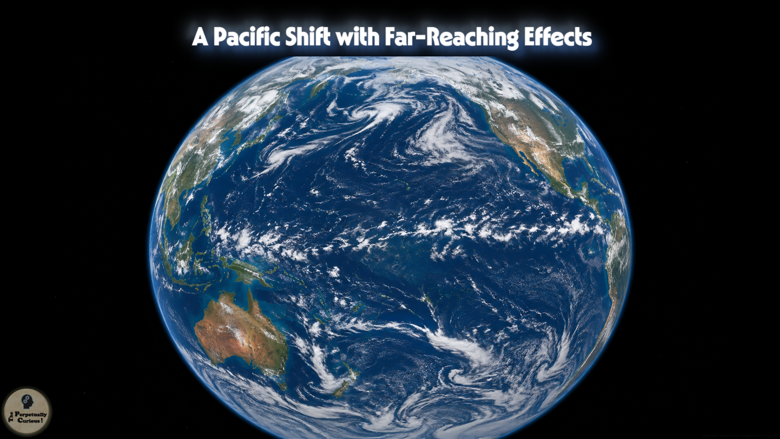
A distant ocean shifts, and the world listens as its breath travels outward.
Patterns of wind and water turn with quiet persistence, touching faraway seasons.
In that slow rearrangement, the planet reveals how deeply its rhythms are shared.
🌊 What El Niño is, really
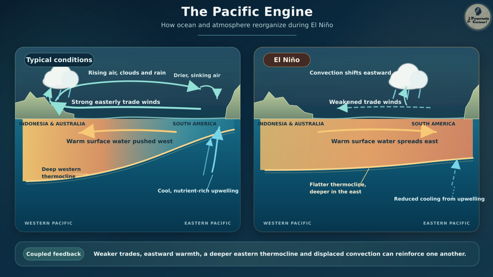
El Niño is the warm phase of a larger climate pattern known as the El Niño–Southern Oscillation, or ENSO. Under typical tropical Pacific conditions, easterly trade winds blow from east to west, pushing warm surface water toward Indonesia and northern Australia. This accumulation of warm water keeps the thermocline, the boundary between the warm upper layer and colder water below, deeper in the western Pacific and shallower near South America. In the east, the shallow thermocline keeps cooler, nutrient-rich water close enough to the surface for upwelling to replenish the upper ocean.
When the trade winds weaken, warm water that has accumulated in the western Pacific can spread eastward. The thermocline deepens across the central and eastern basin, limiting the supply of cool upwelled water and allowing the surface to warm further. As the east-west contrast in ocean temperature and atmospheric pressure diminishes, the trade winds may weaken further. This reinforcing ocean-atmosphere interaction, known as the Bjerknes feedback, can amplify an initial disturbance into a sustained El Niño event, although not every period of weaker winds develops that far.
This coupled development is why climate agencies do not identify El Niño from ocean temperature alone. The US Climate Prediction Center now uses the Relative Oceanic Niño Index, or RONI, as a principal measure for official ENSO monitoring and prediction. RONI compares temperature departures in the Niño 3.4 region with conditions across the wider tropical oceans, helping distinguish warming concentrated in the ENSO region from warming shared more broadly across the tropics. In operational assessments, El Niño conditions require a one-month relative Niño 3.4 departure of at least 0.9°F (0.5°C), an atmospheric response consistent with El Niño, and an expectation that the three-month RONI threshold will be met. For a completed episode to appear in NOAA’s historical record, the RONI threshold must be met across at least five consecutive, overlapping three-month seasons.
As the warmest waters and strongest tropical rainfall shift eastward, they reshape the Walker circulation, the Pacific’s broad east-west loop of surface winds, rising air, upper-level flow, and sinking air. Deep convection becomes more prominent farther east, while sinking air may become more common over parts of the western Pacific. Because tropical rainfall releases substantial heat into the atmosphere, relocating it can disturb large-scale circulation far beyond the basin. That displacement becomes the crucial bridge from a Pacific ocean event to an atmospheric signal capable of reaching around the planet.
🌍 How El Niño reaches the rest of the world
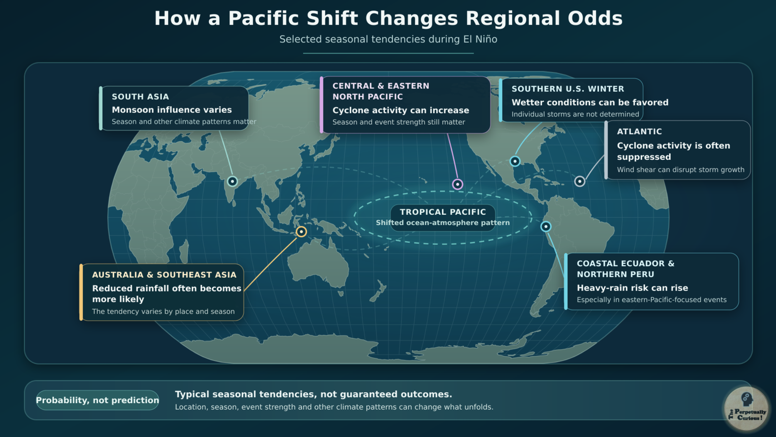
When tropical rainfall shifts eastward during El Niño, an important source of atmospheric heating shifts with it. Heat released as water vapor condenses within towering tropical clouds alters winds high in the atmosphere and can generate planetary-scale wave responses. These disturbances extend into the subtropics and midlatitudes, where they can reposition jet streams, pressure systems, and storm tracks. Such far-reaching relationships are called teleconnections. They change the likelihood of particular seasonal conditions without determining the weather of any individual day or place.
The resulting tendencies differ across regions. When warming is especially pronounced in the eastern Pacific, coastal Ecuador and northern Peru may face a greater likelihood of heavy rainfall and flooding. Across parts of Australia and Southeast Asia, reduced rainfall and prolonged dryness often become more likely. El Niño can also favor greater tropical cyclone activity across the central and eastern North Pacific. Over the Atlantic, by contrast, it commonly strengthens vertical wind shear, which can interfere with developing storms and contribute to a less active hurricane season.
Even these well-established patterns vary among events. Their expression depends on the location and intensity of Pacific warming, the season in which it develops, and its interaction with ocean temperatures, land conditions, and other modes of climate variability. A single El Niño may therefore contribute to drought in one region, heavier seasonal rainfall in another, and only modest or indistinct changes elsewhere.
That complexity becomes particularly clear across South Asia. The monsoon arises from the interaction of seasonal heating, migrating tropical rainfall belts, cross-equatorial winds, Indian Ocean moisture, and regional topography. El Niño can tilt parts of this circulation toward weaker or redistributed rainfall, but it cannot decide the season on its own. Understanding its regional influence therefore requires a closer look at how the monsoon itself works.
🌧 El Niño and the monsoon across India and South Asia
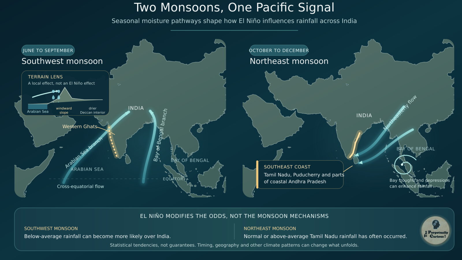
India and the wider South Asian summer monsoon arise from more than a simple contrast between hot land and cooler ocean. As the tropical rain belt moves northward during the Northern Hemisphere summer, changing pressure patterns across the Asian landmass and surrounding seas help establish a broad seasonal circulation. Low-level winds cross the equator and sweep across the Arabian Sea and Bay of Bengal, carrying Indian Ocean moisture toward the subcontinent. Where these moisture-bearing winds converge or terrain forces them upward, the air expands and cools, allowing water vapor to condense into the clouds and rain that define the season.
From June through September, the southwest monsoon supplies roughly three-quarters of India’s annual rainfall, although its contribution and timing vary greatly across the country and the wider region. Mountain ranges help create some of the sharpest contrasts. Along the Western Ghats, moist air rising over windward slopes produces heavy rainfall, while much of the interior Deccan Plateau lies within a drier rain-shadow zone. Elsewhere across South Asia, coastlines, river plains, highlands, and the Himalayan barrier further redistribute the monsoon’s moisture.
When El Niño shifts tropical Pacific warming and convection eastward, the accompanying changes in the Walker circulation can reduce some of the large-scale atmospheric support for the South Asian summer monsoon. Moisture convergence and deep convection may weaken across parts of the region, but the response varies geographically and can change during the season. El Niño therefore raises the probability of below-average Indian summer monsoon rainfall, particularly during some strong events, without determining the outcome of any individual monsoon.
The Indian Ocean Dipole, or IOD, can modify this relationship. During a positive IOD, the western equatorial Indian Ocean becomes warmer relative to waters near Indonesia, and tropical convection tends to shift westward. In some years, the resulting circulation has supported rainfall over India and partly offset El Niño’s drying influence. A negative IOD reverses this ocean-temperature contrast and may make conditions less favorable for Indian monsoon rainfall. Neither phase automatically cancels or reinforces El Niño. Their combined influence depends on their strength, timing, spatial pattern, and interaction with the wider atmosphere.
The summer monsoon is not the region’s final rainfall chapter. From October through December, northeasterly winds crossing the Bay of Bengal, together with troughs, depressions, and cyclonic systems, bring an important later rainy season to southeastern peninsular India. This northeast monsoon is especially important for Tamil Nadu, Puducherry, and parts of coastal Andhra Pradesh. Historical records show that El Niño years have often coincided with normal or above-average northeast monsoon rainfall over Tamil Nadu, although the relationship remains probabilistic. The contrast reveals why the same Pacific event can influence two rainy seasons within one region differently.
Beyond South Asia, the eastward displacement of tropical convection leaves another signature across Southeast Asia and Australia, where suppressed rainfall and prolonged dryness often become more prominent.
🌦 El Niño and rainfall patterns in Southeast Asia and Australia
As El Niño draws tropical convection toward the central and eastern Pacific, rainfall often diminishes across parts of the Maritime Continent. Indonesia and some neighboring areas of Southeast Asia may experience longer dry intervals and below-average rainfall, particularly during the Northern Hemisphere summer and autumn. Because this region is a complex mosaic of islands, seas, mountains, and monsoon systems, the strength and timing of the response can vary sharply over relatively short distances.
When rainfall deficits persist, river flows may decline, soils can lose moisture, and vegetation and crops may face greater water stress. Prolonged dryness can also contribute to conditions that allow agricultural or peatland fires to spread and smoke to linger, although El Niño neither ignites those fires nor determines their severity by itself. Land management, ignition sources, wind, local weather, and earlier moisture conditions remain crucial.
Across Australia, El Niño has historically been associated with reduced winter and spring rainfall, especially across parts of the east and north. Drier soils and vegetation can constrain water supplies, affect agricultural decisions, and elevate fire danger. Yet the pattern is neither uniform nor inevitable. Indian Ocean temperatures, regional sea surface conditions, weather systems, long-term climate trends, and the timing of each event can strengthen, weaken, or redirect El Niño’s influence.
Across both regions, however, a seasonal rainfall total reveals only part of the disruption. The consequences also depend on how often rain falls, whether it arrives as steady replenishing rain or brief downpours, and how long the dry intervals last. To understand what those changing rhythms mean, the story must move from regional climate patterns into the soils, waterways, vegetation, and routines that hold rain close to daily life.
🌱 Landscapes, water, and daily life
The influence of El Niño becomes tangible when altered rainfall changes how water moves through a landscape. When the southwest monsoon delivers less rain across parts of South Asia, rivers may carry less water, reservoirs may receive less inflow, and soils can lose moisture during prolonged breaks between rain events. Similar pressures can develop across parts of Southeast Asia and Australia. Their severity depends on earlier rainfall, existing water reserves, local climate, temperature, land cover, and the duration of the dry period.
A seasonal rainfall total, however, does not fully describe water security. The timing and spacing of rain can affect planting decisions, irrigation demand, reservoir management, and household water availability. Different parts of the water system also respond at different rates. Soil moisture and small water bodies may decline relatively quickly, while some large reservoirs can buffer a single poor season and reflect rainfall accumulated over much longer periods.
Lower seasonal rainfall also does not rule out intense individual downpours. When heavy rain exceeds the rate at which soil can absorb water or drainage systems can carry it away, rapid runoff and localized flooding may follow. The risk can be greater in built-up areas, where roads, rooftops, and other hard surfaces limit infiltration. A brief deluge may therefore raise the season’s rainfall total without replenishing soils and groundwater as effectively as more evenly distributed rain. In parts of South India, seasonal ponds and shallow aquifers reveal how rainfall timing, runoff, infiltration, storage, and local geology together determine where water collects and how long it remains available.
Living systems also respond to the rhythm of rain, not only its total volume. Seasonal combinations of moisture, temperature, and daylight help regulate flowering cycles, migration, breeding, and other recurring biological events. When those cues shift, ecological timing may shift with them, although species and habitats do not respond uniformly. Repeated or severe disruptions can interact with heat, land use, and existing environmental pressures to influence vegetation, wetlands, soil stability, and freshwater habitats.
Because these consequences unfold unevenly and overlap with many other climate influences, drought or flooding in any single region cannot establish that El Niño is present. Scientists instead observe the tropical Pacific directly, following changes in ocean temperature, subsurface heat, winds, atmospheric pressure, and rainfall while an event emerges, strengthens, persists, and eventually fades.
📡 How scientists monitor El Niño
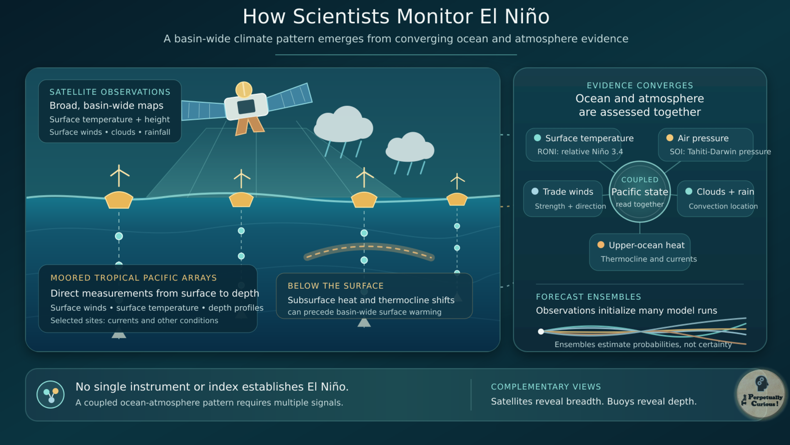
Scientists monitor El Niño by combining measurements made within the tropical Pacific with observations collected from space. Across the equatorial ocean, arrays of moored buoys record surface winds, sea surface temperature, and temperatures through the upper ocean, while some instruments also measure currents and other oceanic or atmospheric conditions. Satellites provide broad maps of sea surface temperature and height, surface winds, clouds, and rainfall. These systems complement one another: satellites reveal basin-wide patterns, while direct measurements show how conditions change beneath the surface.
That subsurface view is essential because the ocean can begin reorganizing before widespread warming becomes visible at the surface. Westerly wind anomalies can generate downwelling equatorial Kelvin waves, pulses of elevated sea level and upper-ocean warmth that travel eastward along the equator. As one of these waves reaches the central and eastern Pacific, it can deepen the thermocline, reduce the cooling influence of upwelling, and support further surface warming. Kelvin waves may help initiate or reinforce El Niño, but their presence does not guarantee that a sustained event will develop. The ocean and atmosphere must continue responding to one another.
Climate centers therefore assess several indicators rather than treating any single measurement as decisive. The Relative Oceanic Niño Index summarizes temperature departures in the Niño 3.4 region relative to the wider tropical oceans, while the Southern Oscillation Index tracks standardized atmospheric pressure differences between Tahiti and Darwin. Negative Southern Oscillation Index values commonly accompany El Niño. Scientists also examine trade winds, subsurface heat, cloud and rainfall patterns, and the location of tropical convection to determine whether the ocean and atmosphere are behaving as a coupled system.
Forecast models use these observations to initialize simulations of the evolving ocean and atmosphere. Scientists compare many model runs and multi-model ensembles to estimate the probabilities that El Niño will strengthen, weaken, persist, or transition toward neutral or La Niña conditions. Differences among the simulations reveal part of the forecast uncertainty. Confidence also varies with lead time, season, subsurface conditions, and how consistently the ocean and atmosphere are reinforcing one another.
These basin-scale observing systems answer a different question from weather radar, which estimates precipitation and tracks storm movement over particular regions. Radar can reveal local weather occurring during an El Niño event, but it cannot determine whether El Niño itself is present. That requires reading the tropical Pacific as an interconnected ocean-atmosphere system. Once those signals are considered together, several less obvious features of El Niño begin to emerge.
Pass this article along to someone curious and let the learning travel.
💡 Did you know?
🗓️ El Niño does not follow a fixed timetable. Events recur irregularly, generally every two to seven years. Many begin developing during Northern Hemisphere spring or summer, strengthen through autumn, and reach their greatest intensity during winter, but their duration and seasonal evolution vary.
🎄 The name El Niño, Spanish for “the little boy,” grew from observations by fishing communities along the Pacific coast of South America. The term originally referred to unusually warm coastal water noticed around the Christmas season. Its scientific meaning later expanded to encompass the much larger coupled ocean-atmosphere pattern recognized today.
🌬️ During many El Niño winters, displaced tropical heating strengthens and shifts the Pacific jet stream eastward and toward the equator. The resulting change in storm tracks can favor wetter conditions across parts of the southern United States, but it does not determine the path, timing, or intensity of any individual storm.
🔭 El Niño forecasts issued during Northern Hemisphere spring often carry greater uncertainty than forecasts made later in the year. This recurring challenge, known as the spring predictability barrier, reflects the reduced skill of forecasts that must anticipate how the tropical Pacific will evolve through its seasonal transition. Uncertainty often decreases once the developing oceanic and atmospheric signals become more clearly established.
🌍 El Niño events do not all warm the Pacific in the same spatial pattern. Some concentrate their strongest temperature departures farther east, while others center them closer to the central Pacific. Because tropical rainfall responds to both the strength and location of that warming, different events can generate different teleconnection patterns. These expressions overlap and are better understood as variations along a continuum than as rigid categories.
🐟 El Niño also reaches beneath the ocean’s surface ecology. When the eastern Pacific thermocline deepens, upwelling may deliver fewer nutrients to sunlit surface waters off western South America. Reduced phytoplankton growth can alter marine food webs, fish distribution, and fisheries, linking a change in ocean circulation with consequences for coastal ecosystems and communities.
Does El Niño create rain directly?
No. El Niño reorganizes large-scale oceanic and atmospheric circulation, changing where rising air, sinking air, moisture convergence, and storm tracks are favored. Rain still develops through local and regional processes involving moisture, uplift, cooling, and condensation. This distinction becomes clearer when examining how clouds and rain form.
How can El Niño affect India’s southwest and northeast monsoons differently?
From June through September, El Niño often raises the likelihood of below-average southwest monsoon rainfall over India, although its timing and strength, Indian Ocean temperatures, the Indian Ocean Dipole, and shorter-term atmospheric variability can modify the outcome. From October through December, El Niño has often been associated with normal or above-average northeast monsoon rainfall over Tamil Nadu and parts of southeastern peninsular India. Because the two monsoons occur during different seasons and arise from different circulation patterns, the same Pacific event need not influence them in the same way.
Why can the same El Niño favor rain in one region and dryness in another?
The displacement of tropical Pacific heating alters atmospheric circulation unevenly around the planet. During particular seasons, El Niño may favor wetter conditions across parts of coastal western South America, the southern United States, and the Horn of Africa, while increasing the likelihood of dryness across parts of Australia, Southeast Asia, southern Africa, and South Asia. These are regional probabilities rather than a universal map of what every El Niño will produce.
Does El Niño affect tropical cyclones in the same way across every ocean basin?
No. Across the eastern and central North Pacific, El Niño often creates more favorable seasonal conditions for tropical cyclone activity. Over the Atlantic, it commonly increases vertical wind shear, which can disrupt the organization of developing storms and suppress seasonal hurricane activity. These basin-wide tendencies do not predict whether any particular storm will form, intensify, or make landfall.
Does El Niño affect temperatures as well as rainfall?
Yes. El Niño changes how heat is exchanged between the tropical Pacific and the atmosphere and often contributes to a temporary rise in global average surface temperature. Regional effects differ, however. Some areas may experience unusual warmth, while others show weaker, delayed, or seasonally variable temperature responses.
Is El Niño related to climate change?
El Niño is a natural mode of climate variability and does not cause long-term climate change. It now unfolds against a warming background driven largely by rising greenhouse gas concentrations. That warmer baseline can intensify associated heat extremes and compound some rainfall, drought, and wildfire impacts. How continued warming may alter the frequency, strength, or spatial pattern of El Niño remains an active area of research.
How does El Niño differ from La Niña?
El Niño is the warm phase of ENSO, while La Niña is its cool phase. Each involves linked changes in Pacific temperatures, trade winds, atmospheric pressure, and tropical rainfall. Their regional effects often lean in opposite directions, but they are not exact mirror images because outcomes depend on season, event strength, location of the strongest temperature departures, and other climate patterns.
Can El Niño be predicted several years in advance?
Scientists can often estimate the likelihood of El Niño several months before it becomes established, although forecast confidence varies with season and lead time. Forecasts that must cross Northern Hemisphere spring are especially challenging because the tropical Pacific is undergoing a seasonal transition. Models can explore longer-range probabilities, but reliably predicting the onset, strength, and timing of a specific El Niño several years in advance remains beyond current operational capability.
🌍 Let the story of distant waters travel farther
If this exploration has made the connection between distant Pacific waters and familiar skies a little clearer, we invite you to share it with friends, colleagues, or fellow learners. Passing it along may help another curious reader discover how changes in one ocean can reshape the probabilities of rain and seasons far beyond it.
“When the Pacific Breathes Warm: El Niño and the Changing Rhythms of Rain.” The Perpetually Curious!, August 2026.
https://www.theperpetuallycurious.org/articles/how-el-nino-affects-weather/Continue Exploring
For what comes next
Site Updates gathers occasional notes, new additions, and ways to keep in touch. RSS brings new publications to your feed reader in chronological order.
Choose the path that speaks to you, and let the next curiosity find you wherever your wondering takes you.