
Far from land, a tsunami may pass beneath a ship as a rise so broad that no one aboard notices. At the coast, the same disturbance can arrive as water advancing steadily across ground that was dry moments earlier. How does a movement that is easy to miss at sea become a flood on land?
A tsunami is a series of unusually long waves set in motion by a sudden disturbance in a body of water. The journey from a slight lift offshore to a surge at the shore begins with what moved the water, then depends on the depths and coastlines the wave encounters.[1]
Beneath the open ocean, the wave may pass almost unnoticed, carried across vast distances by the shape of the seafloor below.
At the shore, that same motion finally reveals itself, connecting distant depths to the places where land and water meet.
🌋 How the seafloor sets water in motion
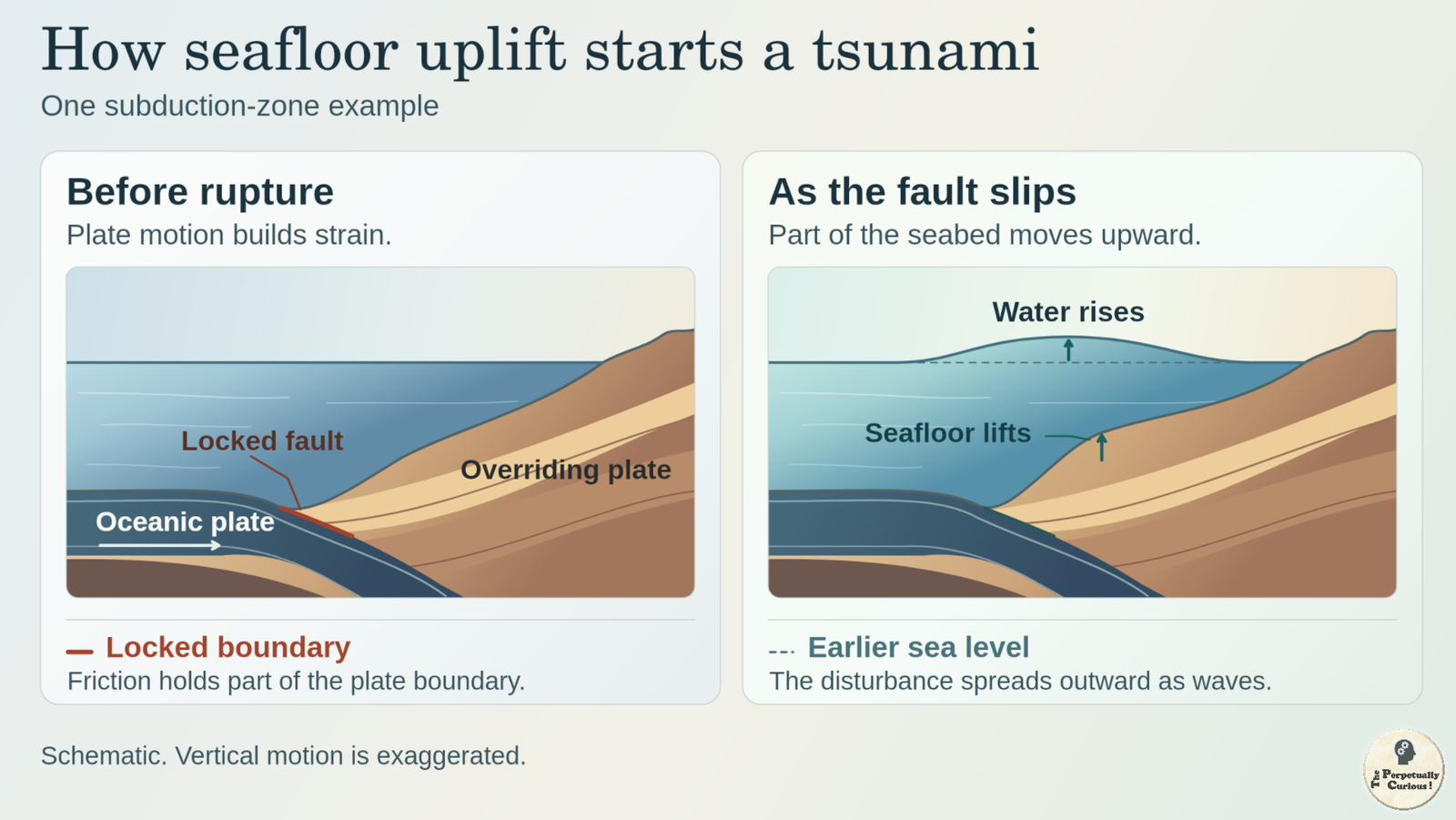
Many large tsunamis begin at a subduction zone, where one tectonic plate descends beneath another. Parts of the plate boundary can lock as the plates continue to move. When the fault breaks, areas of the seafloor may rise or sink abruptly, lifting or lowering the water above them. Gravity pulls the disturbed surface back toward its previous level, and long waves spread away from the source.[1]
The direction of that movement helps explain why earthquake magnitude tells only part of the story. A large rupture that shifts the seabed mainly sideways generally displaces less water directly than a rupture that raises or lowers a broad area. A slide can move water by a different route. Rock falling into a bay or sediment sliding beneath the surface can produce a concentrated disturbance, sometimes with severe consequences close to its source. Volcanic collapses can also displace water, while a fast-moving air-pressure disturbance can generate a long wave called a meteotsunami.[1]
The source sets the water in motion. Once the waves are on their way, their speed depends chiefly on the depth beneath them.
🚢 Why a fast wave can look small offshore
In the deep ocean, tsunami waves are usually no more than about 3 feet (1 meter) high. A typical wavelength, the distance between successive crests, is roughly 60 to 300 miles (100 to 500 kilometers). Spread over such a distance, the rise and fall can be too gradual for a ship’s crew to notice.[1]
That long wave sets water in motion from the surface to the seafloor. Physicists call it a shallow-water wave because even an ocean several miles deep is shallow compared with the wavelength. The standard depth-based estimate puts the wave’s speed at roughly 475 mph (765 km/h) in water about 15,000 feet (4,600 meters) deep.[1] Its approach to land brings it over the rising seabed of the continental shelf.
🏖️ What shallower water changes
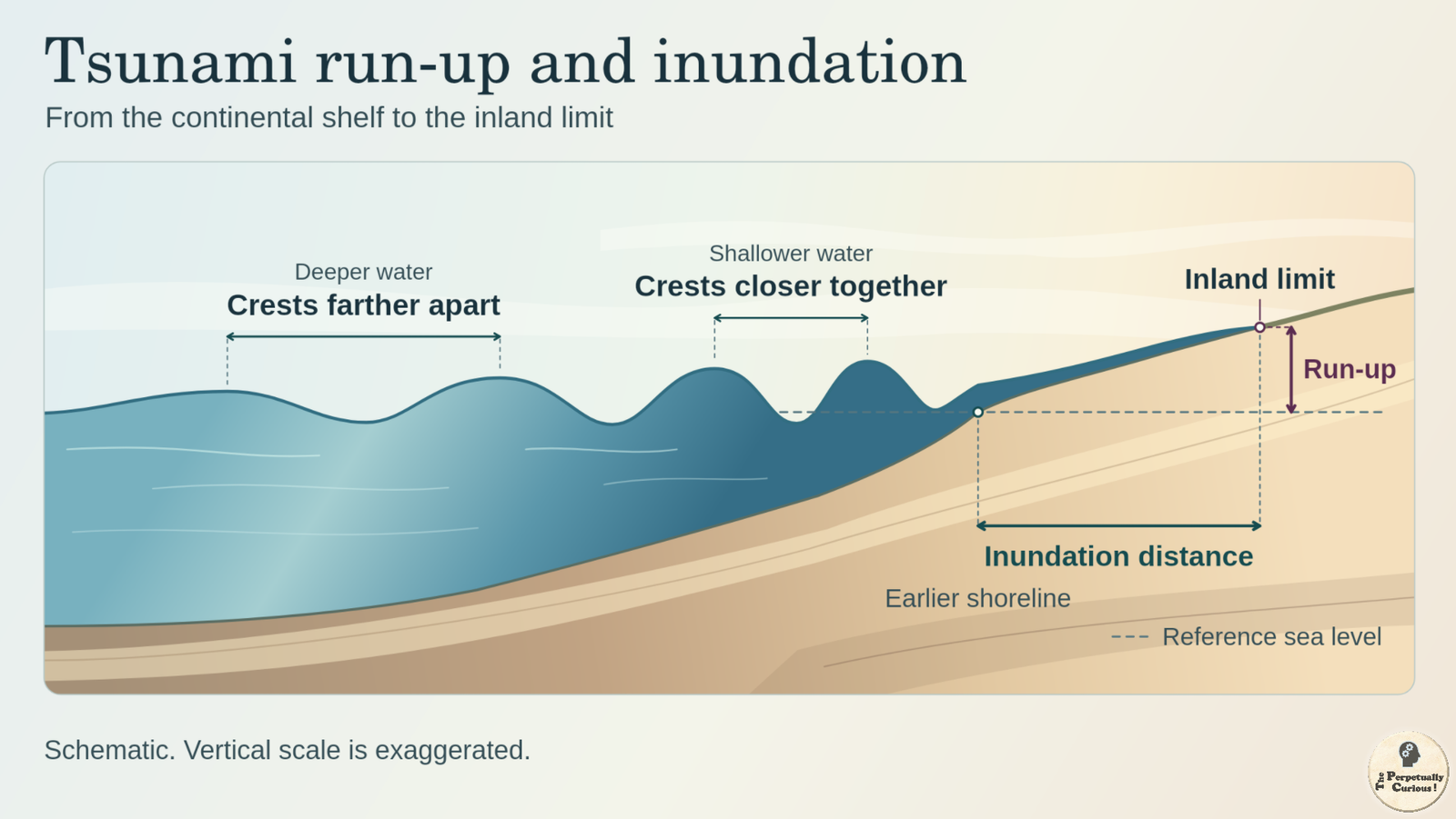
As the tsunami crosses the continental shelf, the underwater margin of a continent, it slows and its crests draw closer together. The wave can also grow taller as it moves into shallower water, an effect called shoaling. Currents can strengthen as well.[1] The shape of the seabed can focus or spread the wave’s energy. Reefs, bays and river mouths can change how the wave reaches a particular stretch of coast.[2]
At the shore, the familiar wind waves that shape sandy beaches often break into surf. A tsunami can arrive as a fast-rising flood or as a steep front of water.
On land, two measurements capture the reach of the flood. Run-up measures the highest elevation the water reaches above a reference sea level along a given section of shore. Inundation distance measures how far inland the water travels. A low, gently sloping plain can flood far inland at a modest elevation, while a steep shore can show high run-up within a much shorter horizontal distance.[2]
The first change at the shoreline depends on which part of the wave arrives.
⏱️ Why the coast rises and falls more than once
If a trough, the low part of the wave, arrives first, the sea can pull back and expose ground that is usually underwater. If a crest arrives first, the water level can rise straight away. Successive crests may be separated by roughly five minutes to two hours. A later wave can be higher than the first, and strong currents can continue between the most visible changes in water level.[2]
In some harbors, incoming waves set the water rocking back and forth at a rhythm shaped by the basin itself. That motion can continue after the first wave has passed.[3] A harbor’s response is local. To follow the tsunami across the ocean, scientists look for a much subtler signal.
📡 How instruments follow the wave
Seismic instruments give forecasters an early estimate of an earthquake’s location, depth and magnitude. Measurements of the ocean show whether a tsunami is passing the instruments. In a DART (Deep-ocean Assessment and Reporting of Tsunamis) system, a pressure recorder on the seabed registers small changes in water pressure as the wave passes. The recorder sends those readings acoustically to a surface buoy, which relays them by satellite. Coastal gauges record the changing water level as waves reach shore.[1]
Forecast models use those observations alongside maps of coastal elevation and bathymetry, the shape and depth of the seabed. Some of the depth data come from mapping the seafloor with SONAR, which measures depth using echoes. As new measurements come in, forecasters can refine estimates of arrival times and coastal effects. A wave generated close to shore can arrive within minutes, leaving little time for those estimates to be refined.[1]
A rise that a ship’s crew might miss can still register on a pressure recorder far below. Farther along the wave’s path, the same disturbance can leave a visible mark where the water reaches up a slope.
Pass this article along to someone curious and let the learning travel.
💡 Did you know?
⚓ The word tsunami comes from the Japanese tsu for “harbor” and nami for “wave.”[1] The name brings to mind the water rocking in a harbor, even when the disturbance began far out at sea.
🌲 In 1958, a rockslide into Alaska’s Lituya Bay sent water up the slope opposite the slide. The upper edge of the forest stripped by the water reached about 1,720 feet (524 meters) above sea level. That mark records the local run-up on the slope.[4]
📜 In 1700, people in Japan recorded a tsunami without feeling the earthquake that caused it. Centuries later, researchers linked those accounts to an earthquake off northwestern North America, using clues that included the rings of trees killed by sudden coastal subsidence. The written record and the trees told different parts of the same Pacific crossing.[5]
Why is “tidal wave” a misleading name?
A tsunami can resemble a tide coming in unusually fast. Astronomical tides follow cycles driven mainly by the gravity of the Moon and Sun. A tsunami begins with a sudden disturbance, and the tide at the time affects the starting water level at the coast.
How is a tsunami different from storm surge?
Storm surge is a rise above the predicted astronomical tide driven mainly by storm winds pushing water toward shore. Low atmospheric pressure can contribute. The flooding associated with nor’easters and coastal storm surge illustrates that process. A tsunami travels as a series of long waves, with successive rises and falls in water level.
Can large lakes experience tsunami-like waves?
Yes. A moving air-pressure disturbance can send a meteotsunami across a lake. A seiche is a standing oscillation in which water rocks back and forth within the basin. In the Great Lakes, strong winds can push water toward one end of a lake, leaving it to rock back and forth after the winds ease.[3]
Does run-up measure floodwater depth?
Run-up is measured relative to sea level. Flood depth is measured above the ground at a specific spot. Water just reaching the top of a slope may be shallow there while covering much lower ground more deeply.
🕊️ Let the story reach another shore
We kindly invite you to share and spread the word with anyone curious about what a quiet ocean can carry.
Selected sources
- National Weather Service (NOAA). Tsunami Frequently Asked Questions.
- National Oceanic and Atmospheric Administration (NOAA). Tsunami Inundation.
- NOAA National Ocean Service. (2026). What is a seiche?
- Miller DJ. (1960). Giant waves in Lituya Bay, Alaska. U.S. Geological Survey Professional Paper 354-C.
- Atwater BF, Musumi-Rokkaku S, Satake K, et al. (2005). The orphan tsunami of 1700. Japanese clues to a parent earthquake in North America. U.S. Geological Survey Professional Paper 1707.
“How Tsunamis Work: The Long Journey from Seafloor to Shore.” The Perpetually Curious!, November 2026.
https://www.theperpetuallycurious.org/articles/how-tsunamis-work/Continue Exploring
For what comes next
Site Updates gathers occasional notes, new additions, and ways to keep in touch. RSS brings new publications to your feed reader in chronological order.
Choose the path that speaks to you, and let the next curiosity find you wherever your wondering takes you.