

Rain arrives in many forms, from a quiet drizzle that softens a morning landscape to a sweeping downpour that transforms streets and fields. Although familiar, every rainfall begins with an atmospheric story unfolding above us. Moist air rises and cools, invisible vapor gathers around tiny airborne particles, and countless droplets or ice crystals take shape within clouds. Understanding why it rains reveals how these particles remain suspended, how they grow, and how they eventually fall to nourish rivers, soils, and living systems.
Rain has shaped human experience across cultures and centuries. It appears in poetry, music, art, and tradition, often symbolizing renewal, reflection, cleansing, fertility, or change. These meanings vary among communities, but together they add a quiet emotional layer to the scientific story, reminding us that rain is both a physical process and a deeply shared human experience.
The journey begins with invisible vapor, moves through cloud formation, and continues into the microphysical processes that allow droplets or ice particles to grow large enough to fall. What appears at the surface as a simple change in the weather is the culmination of a quiet and intricate sequence of atmospheric steps.
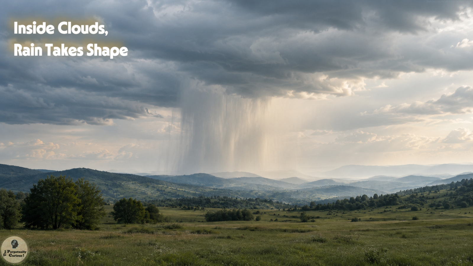
Rain gathers in the sky with a patience that feels almost human, rising and falling in its own quiet rhythm.
Each drop carries a small memory of the air that shaped it, a brief passage through light and motion.
When it reaches the ground, it becomes a gentle reminder that the atmosphere is always at work, even when the world below seems still.
☁️ From invisible vapor to visible clouds
Water enters Earth’s atmosphere as vapor through evaporation from oceans, lakes, and soils, and through transpiration from vegetation. Moist air may rise through surface heating and convection, along weather fronts, or when moving air is forced over elevated terrain. As the air rises, it expands and cools. Because saturation is reached at a lower water-vapor concentration as temperature falls, the cooling air may become saturated or slightly supersaturated, allowing some of its vapor to condense into liquid droplets.
Condensation usually begins on tiny airborne particles called cloud condensation nuclei. Sea salt, dust, smoke, and other aerosols can provide surfaces on which water molecules gather. Many of these particles are hygroscopic, meaning that they readily attract water. As cooling continues, suitable nuclei become activated, and water vapor condenses onto them, producing countless microscopic droplets.
Cloud droplets vary in size, but a representative droplet may measure about 0.0008 inch (20 micrometers) across. At this scale, droplets fall extremely slowly, and even gentle upward air currents can keep them suspended. A cloud is therefore a visible collection of tiny water droplets, ice crystals, or both, large enough to scatter light but ordinarily too small to fall as precipitation.
This microscopic scale helps explain how clouds can drift overhead without immediately releasing rain. To understand why some clouds eventually produce precipitation while others do not, the next step is to follow how their droplets and ice particles grow beyond this suspended state.
🌧️ Why clouds do not always rain
Many clouds contain substantial amounts of water yet release no rain because most of their droplets remain too small to descend through the surrounding air. A typical cloud droplet may fall at only a few centimeters per second, a speed that can be matched or exceeded by gentle upward currents. The droplets therefore remain suspended, allowing the cloud to persist without producing precipitation at the surface.
To become rain, these droplets must increase enormously in volume. Condensation is essential during their early growth, but it generally becomes too slow to carry ordinary cloud droplets across the full size gap to precipitation within a cloud’s lifetime. Other microphysical processes must broaden the range of droplet and ice-particle sizes until some particles develop fall speeds strong enough to overcome the surrounding upward motion.
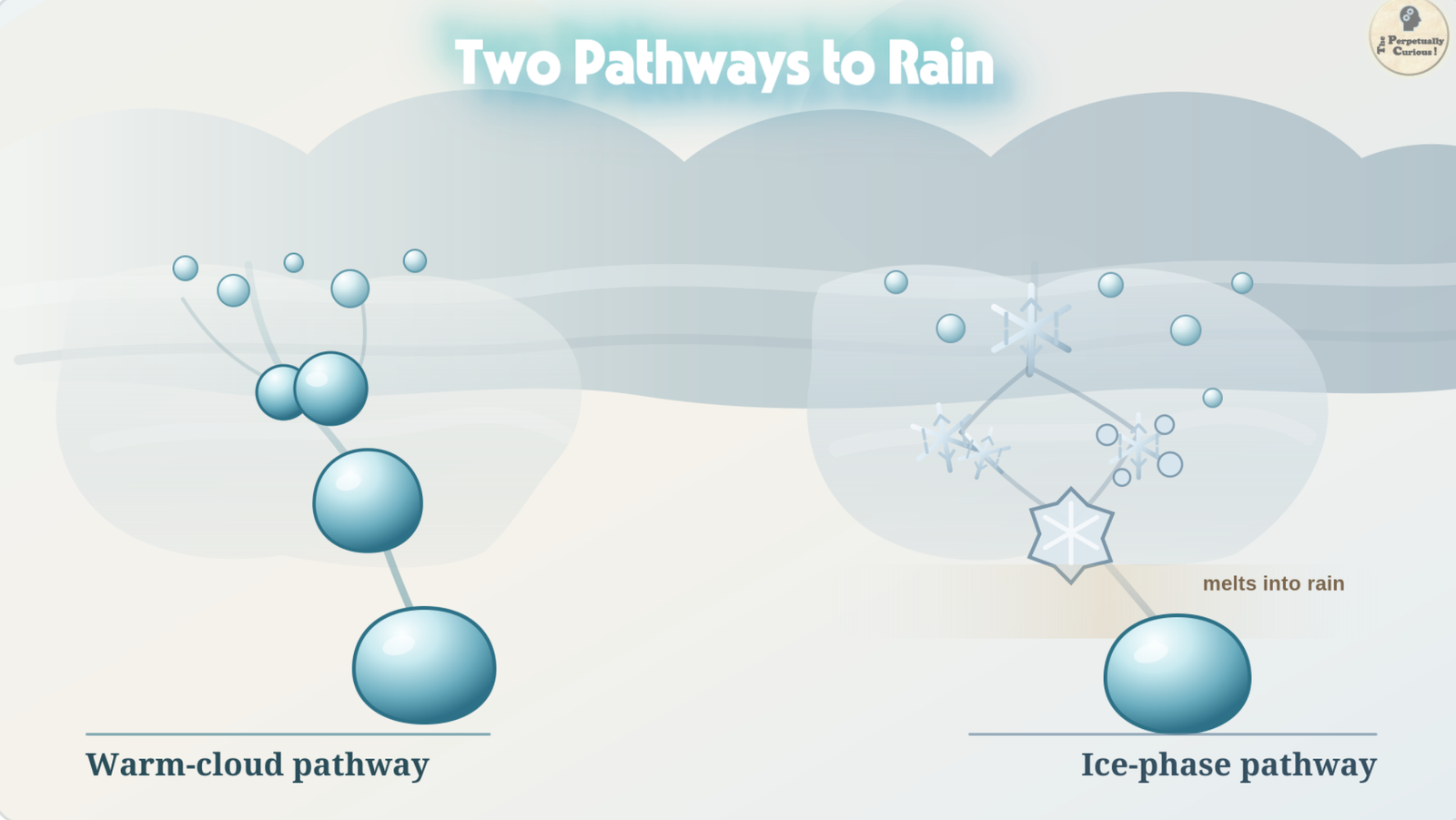
This leads to two principal pathways of precipitation growth. In warmer cloud regions, liquid droplets may enlarge through repeated collisions and coalescence. In colder or mixed-phase regions, ice crystals can grow through vapor deposition, collisions, and the collection of supercooled droplets before melting into raindrops as they descend through warmer air.
🌤️ Warm clouds and the collision and coalescence story
In clouds or cloud regions where temperatures remain above freezing, rain can form through collision and coalescence. The process begins with a range of droplet sizes. Some droplets may begin slightly larger because they form on especially large or soluble condensation nuclei, while others spend more time in regions favorable to condensation and continued growth.
Larger droplets generally fall faster than smaller ones. As they descend relative to the surrounding cloud droplets, they may overtake and collide with those in their path. When a collision leads to merging, or coalescence, the result is a single larger drop. Repeated collisions can gradually transform microscopic cloud droplets into drops large enough to fall as precipitation.
This growth does not proceed equally efficiently at every size. Many small droplets follow similar air motions and therefore do not collide readily, while some collisions fail to produce lasting coalescence. Turbulence can increase the number of encounters by bringing droplets of different sizes together. Once a few collector drops become sufficiently large, their faster descent allows them to gather smaller droplets more effectively, and their growth can accelerate.
Drops larger than about 0.02 inch (0.5 millimeter) are generally classified as raindrops rather than drizzle droplets. A drop measuring about 0.08 inch (2 millimeters) is already a moderate-to-large raindrop with a substantial fall speed. Warm-rain processes are especially important in tropical and subtropical clouds, although collision and coalescence can also occur in the above-freezing portions of clouds that contain ice higher aloft.
Clouds often contain several temperature layers. When droplets are carried into regions below freezing, liquid water and ice may coexist, opening a second pathway through which precipitation can grow.
❄️ Cold clouds and the ice-phase pathway
In clouds that extend into subfreezing air, liquid droplets and ice crystals may coexist. Many liquid droplets remain unfrozen even below 32°F (0°C) and are therefore described as supercooled. Ice-nucleating particles help initiate some crystals, and under suitable mixed-phase conditions, this combination allows an important growth mechanism known as the Bergeron-Findeisen process to operate.
At the same subfreezing temperature, the saturation vapor pressure over ice is lower than it is over liquid water. Air that is saturated, or even slightly subsaturated, with respect to liquid droplets may therefore remain supersaturated with respect to ice. Under these conditions, water vapor deposits preferentially onto ice crystals, allowing them to grow.
As deposition continues, some nearby supercooled droplets may evaporate slightly and replenish the surrounding vapor. Growing crystals can also collide and join with other ice particles through aggregation. As they move through the cloud, they may collect supercooled droplets that freeze onto their surfaces through a process called riming, sometimes producing graupel or other larger ice particles.
If these particles descend through air warmer than 32°F (0°C), they may melt and reach the ground as raindrops. Many rain events in temperate regions begin this way, with precipitation forming as ice aloft and changing into liquid water during descent.
Warm-rain and ice-phase processes can operate within different regions of the same cloud. Their relative importance depends on temperature, moisture, cloud depth, particle populations, and the movement of air within the cloud, which leads naturally to the role of atmospheric motion in shaping rainfall.
🌬️ Atmospheric motions and the making of rainfall
Clouds exist within moving air. Rising and sinking currents, horizontal winds, and turbulence influence where droplets and ice particles travel, how long they remain inside the cloud, and how efficiently they grow.
Updrafts carry cloud particles upward and can keep them within moist regions where condensation, vapor deposition, and collection continue. Strong updrafts are common in deep convective clouds such as thunderstorms, whose towers may rise above 30,000 feet (about 9,000 meters), with the most vigorous storms extending considerably higher. By moving droplets and ice particles through regions with different temperatures and moisture conditions, these currents can lengthen the time available for growth.
Downdrafts carry air and precipitation downward. They may be strengthened by precipitation drag and by evaporative cooling beneath the cloud. As rain-cooled air approaches the surface, it can spread outward as a gust front, causing winds to strengthen before the main rain shaft arrives. When sufficiently large drops or ice particles enter descending currents, precipitation may begin rapidly at the surface.
Turbulence creates irregular, swirling motions that bring particles of different sizes into contact and can increase collision rates. Mixing near cloud boundaries is more complex. It may create small pockets where additional growth occurs, but it can also introduce drier air that promotes evaporation. Electrical forces may modestly influence some particle encounters, although these effects are generally secondary to thermodynamic conditions, turbulence, and differences in fall speed.
Once droplets or ice particles become large enough to descend through the surrounding air, their size, concentration, and journey below the cloud help determine whether the surface receives a faint drizzle or a sudden downpour.
💧 From drizzle to downpour: how raindrops reach the ground
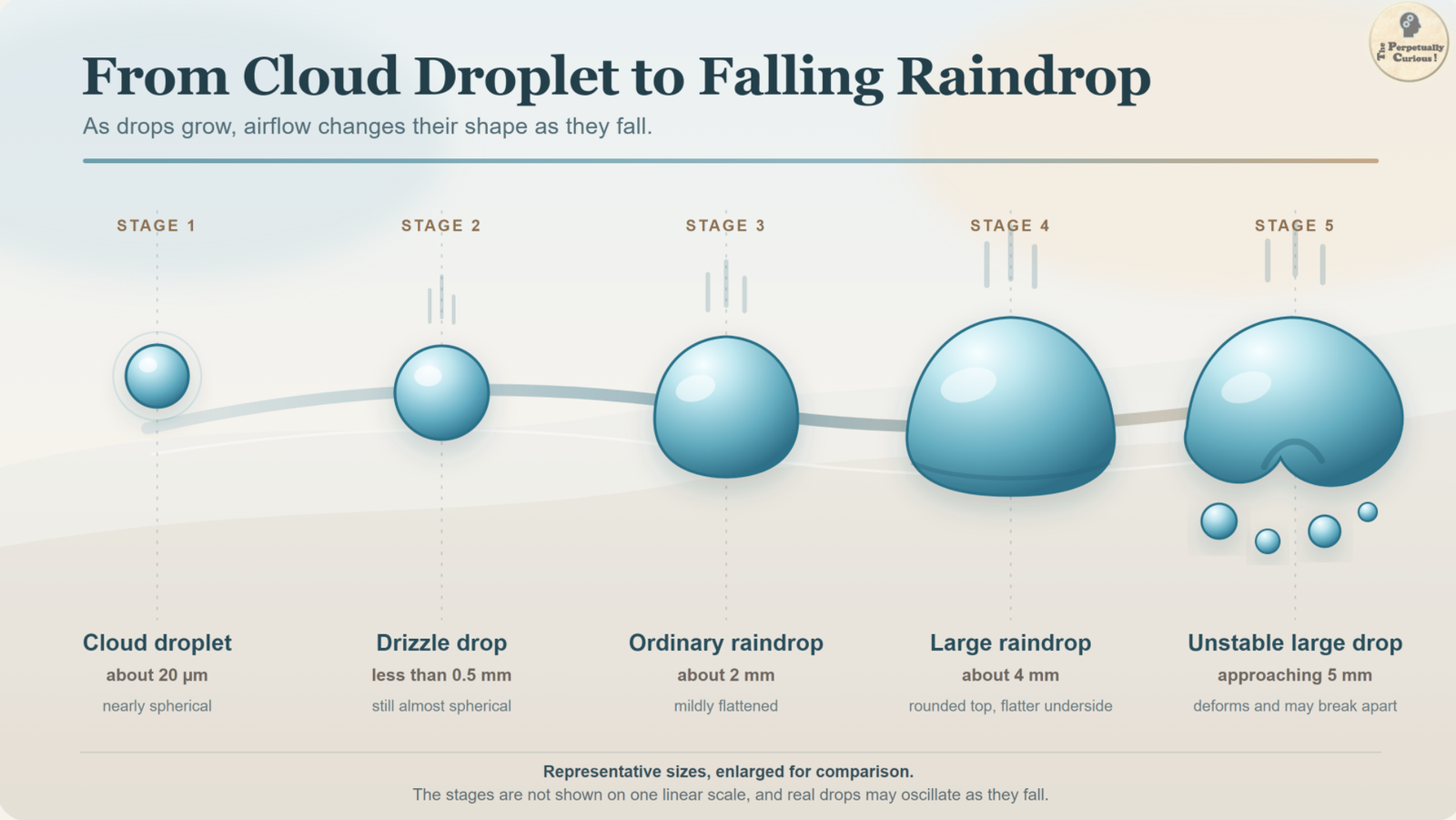
Rainfall intensity depends on more than the size of individual drops. It reflects how many drops reach the surface during a given interval, their range of sizes, their fall speeds, and the depth and motion of the precipitating cloud. Drizzle usually consists of very small drops less than about 0.02 inch (0.5 millimeter) across, which fall relatively slowly. Drops around 0.08 inch (2 millimeters) are already moderate-to-large raindrops and can contribute substantially to heavier rainfall when they occur in sufficient numbers.
As drops grow larger, aerodynamic forces increasingly distort their shape. Very large drops approaching about 0.2 inch (5 millimeters) may oscillate, become unstable, and break into smaller drops as they fall.
The air below the cloud also matters. Raindrops may evaporate partially, or sometimes completely, when they pass through a dry layer. This reduces the amount of water reaching the ground and cools the surrounding air, which can strengthen descending currents beneath the cloud. When precipitation evaporates completely before reaching the surface, it may appear as streaks beneath the cloud known as virga.
Each raindrop therefore carries the history of its journey, shaped by some combination of condensation, collisions, coalescence, freezing, melting, evaporation, gravity, and drag from the surrounding air.
🔊 The sensory physics of rain
Rain does not only fall. It arrives with sound. The familiar patter begins when drops strike leaves, roofs, soil, puddles, and other surfaces, setting each material into its own pattern of vibration. Drop size and fall speed influence the impact, but the resulting sound also depends on the shape, texture, stiffness, and resonance of the surface below.
On open water, some impacts create tiny cavities or briefly trap bubbles that can resonate beneath the surface. Leaves bend and release energy differently from metal roofs, while soft soil absorbs much of the impact. Rainfall therefore produces not one universal sound, but a shifting acoustic landscape shaped by water, material, motion, and place.
Wind, surrounding noise, terrain, and the temperature structure of the lower atmosphere can further influence how these sounds travel to a listener. Rain does not necessarily become softer at night, but it may seem different as background noise, air movement, and atmospheric conditions change. These variations add another sensory layer to the physics of falling water.
The same impacts that create this acoustic landscape also strike soil and stone, opening the wider story of how rainfall reshapes the land.
🏞️ Rain as a sculptor of landscapes
A single raindrop may leave little visible trace, but rainfall repeated across seasons and centuries becomes a geological force. Drop impacts can loosen exposed soil particles, while runoff transports sediment downslope and into streams, wetlands, and rivers. Through weathering, erosion, transport, and deposition, rain contributes to soil formation and the gradual reshaping of the land.
Where water infiltrates permeable ground, it can replenish soil moisture and help recharge groundwater. Where intense or prolonged rainfall exceeds the ground’s ability to absorb water, rapid runoff may erode slopes, deepen channels, and sometimes contribute to floods or landslides. The outcome depends on rainfall intensity and duration, as well as vegetation, soil properties, slope, geology, and existing moisture conditions.
Through these accumulated effects, rainfall participates quietly but persistently in the continuous transformation of Earth’s surface.
🌍 Rain in the grand water cycle
The water that reshapes the land does not remain there. It continues through a larger cycle linking oceans, land, the atmosphere, and living organisms. Water evaporates from oceans, lakes, rivers, wetlands, and soils, while plants release additional vapor through transpiration. After traveling through the atmosphere, some of this moisture condenses into clouds and eventually returns as precipitation. Water that reaches the land may flow into rivers, infiltrate soils, recharge aquifers, collect in lakes and wetlands, or return to the atmosphere through evaporation and plant activity.
The distribution of rainfall across the planet is shaped by large-scale atmospheric circulation, the movement of weather systems, and the contours of the land. Near the equator, warm, moisture-rich air frequently rises and produces abundant rainfall. In many subtropical regions, descending air favors drier conditions. Farther poleward, fronts and midlatitude cyclones bring alternating periods of precipitation and clearer weather.
Topography adds another layer to this pattern. Mountain ranges force moving air upward, causing it to expand and cool. This often increases rainfall on windward slopes while creating drier rain-shadow regions on the leeward side. Moisture-rich landscapes such as the Great Smoky Mountains offer a familiar expression of how elevation, airflow, clouds, and precipitation interact.
Large-scale circulation, weather systems, moisture supply, and topography help determine where air rises and where clouds are likely to develop. Within those clouds, smaller-scale processes such as condensation, collision, coalescence, vapor deposition, freezing, and melting determine whether atmospheric moisture ultimately becomes precipitation. Rain therefore connects microscopic interactions inside clouds with the broader rhythms of weather, climate, and hydrology.
🌙 A quiet moment with falling water
When rain begins to fall, it may seem like a simple change in the weather. Yet every shower carries the imprint of rising and cooling air, invisible vapor gathering around microscopic particles, and droplets or ice crystals growing within clouds. Some raindrops form through repeated collisions between liquid droplets, while others begin as ice aloft and melt during their descent. The sound of rain on roofs, leaves, and sidewalks becomes the audible trace of these countless atmospheric steps unfolding above.
To watch rain is to witness the atmosphere returning what it has gathered, bringing water back to the surface in a form that is both familiar and scientifically intricate. Each rainfall becomes a gentle reminder of the sky’s continuous work of gathering, transforming, and returning water.
Pass this article along to someone curious and let the learning travel.
💡 Did You Know?
🌧️ A raindrop’s journey may begin as ice
Precipitation can form as an ice crystal or snow particle in a cold upper region of a cloud, melt while passing through warmer air, and then continue through another cloud layer before reaching the ground. Its journey may span thousands of feet and several distinct atmospheric environments.
🌫️ Fog forms like a cloud at ground level
Fog develops when air near the surface becomes sufficiently saturated for tiny suspended droplets to form. These droplets are similar to those inside clouds, although fog usually produces little or no measurable precipitation.
☁️ More condensation nuclei do not always mean more rain
When many cloud condensation nuclei are present, the available water may be divided among a larger number of smaller droplets. In some warm clouds, this can delay collision and coalescence, although the outcome also depends on moisture, turbulence, cloud depth, and atmospheric motion.
🌦️ Falling liquid water may refreeze before reaching the ground
When melted precipitation passes through a sufficiently deep layer of subfreezing air, it can refreeze into ice pellets. If the cold layer is shallower, the drops may instead remain supercooled and freeze when they strike exposed surfaces, producing freezing rain.
🌈 Falling drops can become tiny optical elements
When sunlight is refracted as it enters raindrops, reflected inside them, and refracted again as it leaves, the same water involved in rainfall can produce rainbow formation. Because the geometry depends on the positions of the Sun, the droplets, and the observer, each person effectively sees a slightly different rainbow.
💧 Raindrops change shape as they fall
Small raindrops are nearly spherical because surface tension pulls their water inward. Larger drops become increasingly flattened by airflow, while very large drops may oscillate, become unstable, and break into smaller ones.
Why does it rain from some clouds but not others?
Rain develops only when droplets or ice particles grow large enough to descend through the surrounding air and survive the journey to the ground. In many clouds, these particles remain microscopic and are kept suspended by weak upward currents.
How long does it take for a raindrop to form?
There is no single formation time. In rapidly developing clouds, precipitation-sized drops or ice particles may emerge within tens of minutes. Slower-growing clouds may take longer or produce no rain at all. Temperature, moisture, turbulence, particle sizes, and cloud depth all influence the process.
Can rain form without ice inside the cloud?
Yes. In warm clouds or above-freezing cloud regions, liquid droplets can grow through repeated collisions and coalescence without first becoming ice. Other raindrops begin as snowflakes, graupel, or ice crystals aloft and melt during their descent.
Are all raindrops the same size?
No. Raindrops occur across a range of sizes. Drizzle usually consists of drops smaller than about 0.02 inch (0.5 millimeter), while ordinary rain contains larger drops of varying diameters. A shower may therefore contain many small drops together with fewer moderate or large ones.
What is the difference between rainfall intensity and rainfall amount?
Rainfall intensity describes how quickly rain is falling during a particular interval. Rainfall amount is the total depth of water accumulated over time. A brief downpour may have high intensity but produce less total water than gentle rain that continues for several hours.
Can rain evaporate before reaching the ground?
Yes. Rain may evaporate partly or completely while falling through dry air beneath a cloud. When precipitation evaporates before reaching the surface, the visible streaks below the cloud are often called virga. This evaporation also cools the surrounding air.
Does rain always come from tall clouds?
No. Low, layered clouds can produce drizzle or light, persistent rain. Deeper clouds are more commonly associated with heavy showers and thunderstorms because they provide greater vertical distance and more varied conditions for droplets and ice particles to grow.
Can rain begin suddenly even when the sky looks unchanged?
Yes. Processes inside a cloud may change before any obvious difference is visible from the ground. Rain can begin quickly once enough droplets or ice particles reach precipitation size, or when a nearby rain shaft moves over the observer.
Why do some storms produce very large raindrops?
Large drops can grow when faster-falling collector drops repeatedly collide and merge with smaller droplets. They may also form when large snow particles, graupel, or other ice particles melt below the freezing level. Strong updrafts can extend the time available for growth, but repeated freezing and melting are not required.
Why does the wind sometimes strengthen before rain begins?
A thunderstorm downdraft can carry rain-cooled air toward the ground. When that denser air reaches the surface, it spreads outward as a gust front or outflow boundary. The moving air may reach an observer before the main rain shaft, producing a sudden breeze or strong gusts ahead of the rainfall.
Why can thunder and lightning occur before the rain arrives?
Lightning may begin within electrically active regions of a thunderstorm while the main rain shaft is still some distance away or while much of the precipitation remains aloft. Thunder is the sound produced when lightning rapidly heats and expands the surrounding air. Neither phenomenon requires rain to have reached the observer first.
How does hail form, and can it fall when surface air is warm?
Hail develops inside thunderstorms with strong updrafts that carry ice particles through regions containing supercooled droplets. The droplets freeze onto the particles, allowing layers of ice to accumulate until the hailstones become too heavy for the updraft to support. Because hail forms high inside the cloud, it can reach the ground even when surface temperatures are above freezing.
Why does rain sometimes stop even though the cloud remains overhead?
A cloud may remain visible after its precipitation-producing region has weakened or moved away. Rain can stop when droplet or ice-particle growth slows, upward motion changes, moisture decreases, or falling precipitation evaporates before reaching the ground.
Why does rain sometimes smell different in different places?
The scent of rain, often called petrichor, varies with local soils, vegetation, microorganisms, and weather conditions. Raindrop impacts can release tiny aerosols and volatile compounds, including plant-derived substances and the earthy-smelling compound geosmin, into the surrounding air.
Why do rain clouds sometimes look almost black?
Rain clouds do not become truly black. Thick, deep clouds create long and complex paths through which sunlight must travel. Repeated scattering redirects much of the incoming light before it reaches the cloud base, causing the underside to appear dark gray or nearly black, especially against brighter surrounding sky.
How do meteorologists detect rain inside clouds?
Systems such as weather radar send radio pulses into the atmosphere and measure echoes returned by raindrops, snowflakes, and ice particles. The strength, timing, and motion of those echoes help meteorologists locate precipitation, estimate its intensity, and observe how it is moving.
Can rain be seen from space?
Individual raindrops are too small to be resolved separately from orbit. Broad rain bands, storm systems, and precipitation shafts can nevertheless be observed or mapped from space. Satellite instruments use visible, infrared, microwave, and radar measurements to estimate the location, structure, and intensity of rain and snow.
What does rain look or feel like from inside an airplane?
From a passenger cabin, rain may appear as rapidly moving streaks across the windows and may produce a change in exterior sound. Inside a cloud, the view outside may become pale or obscured. Rain can accompany turbulence in active weather systems, although rainfall by itself does not necessarily mean that the air will be rough.
Why are some parts of Earth much rainier than others?
Regional rainfall depends on moisture supply, prevailing winds, atmospheric circulation, seasonal weather systems, elevation, and topography. Places where moisture-rich air is repeatedly forced upward often receive abundant precipitation, while regions dominated by descending air or rain-shadow effects may remain much drier.
Why can a place feel very rainy without receiving extreme annual rainfall?
A place may seem especially rainy because precipitation occurs frequently, skies remain cloudy, or light rain and drizzle persist across many days. This does not necessarily mean that its annual rainfall total is exceptionally high. Seattle, for example, is known more for frequent cool-season cloudiness and recurring light precipitation than for continuous rain or record-breaking yearly totals. Its summers can also be comparatively dry.
Why do some places receive exceptionally heavy rainfall?
Exceptionally wet regions often combine a large moisture supply with terrain that repeatedly forces air upward. Mawsynram and nearby Cherrapunji, also known as Sohra, lie in the Khasi Hills of northeastern India. During the monsoon, moisture-rich air arriving from the Bay of Bengal is lifted rapidly by the terrain, leading to strong cooling, condensation, and exceptionally heavy rainfall.
Can large lakes influence nearby rain or snow?
Yes. Large lakes can supply heat and moisture to passing air and alter local atmospheric conditions. When cold air moves over relatively warmer water, bands of lake-effect precipitation may develop downwind. The Great Lakes provide a striking example, producing snow during cold conditions and sometimes rain when temperatures are warmer.
Is rainwater naturally pure?
Rainwater often begins with relatively little dissolved mineral matter, but it is not chemically pure or automatically clean. Cloud droplets and falling rain can absorb gases and collect dust, aerosols, microorganisms, and pollutants from the atmosphere. Rain is also naturally mildly acidic because carbon dioxide dissolves in water, and collected rainwater may acquire additional contaminants from roofs or storage surfaces.
Why do plants often seem greener or more vigorous after rain?
Rain can wet a broad area of soil, reduce plant water stress, wash dust from leaves, and create cooler, more humid conditions. Its lasting benefit depends on how deeply the water infiltrates, how well the soil drains, and patterns of root access to stored water. Rain is not inherently superior to properly applied irrigation, but it may wet the surrounding soil more broadly than brief or localized surface watering.
Why do mushrooms often appear after rain?
The visible mushroom is a fruiting structure produced by fungal mycelium that was already present in soil, leaf litter, or wood. Rain can moisten a broad substrate, raise humidity, and create suitable temperature conditions for fruiting. The mushroom therefore appears after rain, but the underlying fungus was already present.
Can artificial watering cause mushrooms to appear?
Yes. Irrigation can trigger mushroom production when it creates sufficiently moist and humid conditions for long enough. Brief or localized hose watering may not reproduce the broad, sustained moisture and environmental changes associated with rainfall, which is why the response can differ.
Does rain occur anywhere else in the Solar System?
Earth is the only known world where widespread liquid-water rain regularly reaches the surface today. Other worlds have very different forms of precipitation, including methane rain on Titan, sulfuric-acid droplets on Venus that generally evaporate before reaching the ground, and water-ice or carbon-dioxide snow on Mars. These examples of precipitation across our Solar System show how temperature, pressure, atmospheric composition, and available materials determine what can fall from a world’s sky.
Why is rain associated with renewal in many stories and traditions?
Rain restores visible moisture to landscapes, supports seasonal growth, and often follows periods of heat or dryness. These recurring natural patterns have made rain a symbol of renewal, cleansing, fertility, transition, and emotional release in many artistic and cultural traditions. Such meanings are not universal and vary across communities, environments, and historical contexts.
🌱 Let the Quiet Rain Travel On
Under this gentle sky of ideas, we encourage you to help this piece reach a wider audience by sharing it with friends, colleagues, and fellow curious readers. Your support is deeply appreciated, and each shared link becomes a small ripple in a wider conversation about how rain takes shape, how the atmosphere moves water, and why this familiar phenomenon matters.
“When Clouds Let Go: Why It Rains and How Raindrops Are Born.” The Perpetually Curious!, July 2026.
https://www.theperpetuallycurious.org/articles/why-does-it-rain/Continue Exploring
For what comes next
Site Updates gathers occasional notes, new additions, and ways to keep in touch. RSS brings new publications to your feed reader in chronological order.
Choose the path that speaks to you, and let the next curiosity find you wherever your wondering takes you.